IMAGES TAKEN NEAR TO
Dunscore, DUMFRIES, DG2 0UX
Introduction
This page details the photographs taken nearby to DG2 0UX by members of the Geograph project.
The Geograph project started in 2005 with the aim of publishing, organising and preserving representative images for every square kilometre of Great Britain, Ireland and the Isle of Man.

There are currently over 7.5m images from over14,400 individuals and you can help contribute to the project by visiting https://www.geograph.org.uk
Image Map
Images are licensed for reuse under creativecommons.org/licenses/by-sa/2.0
Notes
- Clicking on the map will re-center to the selected point.
- The higher the marker number, the further away the image location is from the centre of the postcode.
Image Listing (7 Images Found)
Images are licensed for reuse under creativecommons.org/licenses/by-sa/2.0
Image
Details
Distance
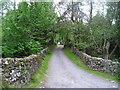
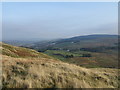
2
Road down Glenesslin
The start of a long descent at Craigenputtock.
Image: © Richard Webb
Taken: 6 Oct 2018
0.11 miles
3
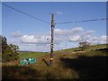
New poles
Renovation of a power line at Craigenputtock. There was a generator running, providing power while the lines are being restrung. Coincidently there was also a fair few new telephone poles going up too.
Image: © Richard Webb
Taken: 6 Oct 2018
0.13 miles
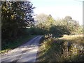
4
Road to Nether Craigenputtock
Looking south-westward.
Image: © Peter Wood
Taken: 16 Sep 2017
0.21 miles
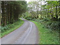
6
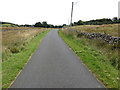
Road to Nether Craigenputtock
Looking north-eastward.
Image: © Peter Wood
Taken: 16 Sep 2017
0.22 miles
7
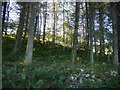
Woodland, Craigenputtock
The trees on the opposite side of the road were being felled, so this small wood may not be there now.
Image: © Richard Webb
Taken: 6 Oct 2018
0.25 miles