IMAGES TAKEN NEAR TO
Dunscore, DUMFRIES, DG2 0UP
Introduction
This page details the photographs taken nearby to DG2 0UP by members of the Geograph project.
The Geograph project started in 2005 with the aim of publishing, organising and preserving representative images for every square kilometre of Great Britain, Ireland and the Isle of Man.

There are currently over 7.5m images from over14,400 individuals and you can help contribute to the project by visiting https://www.geograph.org.uk
Image Map
Images are licensed for reuse under creativecommons.org/licenses/by-sa/2.0
Notes
- Clicking on the map will re-center to the selected point.
- The higher the marker number, the further away the image location is from the centre of the postcode.
Image Listing (6 Images Found)
Images are licensed for reuse under creativecommons.org/licenses/by-sa/2.0
Image
Details
Distance
1
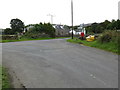
Junction of roads in Milton
Looking south-eastward.
Image: © Peter Wood
Taken: 16 Sep 2017
0.08 miles
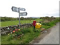
2
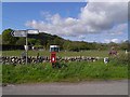
Road junction at Milton
A "horsey" establishment in the background.
Image: © Oliver Dixon
Taken: 24 May 2009
0.08 miles
3
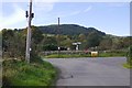
Road junction, Milton
Featuring an old telegraph pole and a recently erected new one. Openreach engineers were working nearby.
Image: © Richard Webb
Taken: 6 Oct 2018
0.08 miles
4
Junction, Milton
The tulips were apt, about ten Harley Davidson bikes passed - a Dutch club run by the look of it. They obviously know a good road.
The mapped telephone box has disappeared.
Image: © Richard Webb
Taken: 23 May 2013
0.09 miles
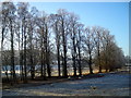
5
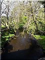
Glenesslin Burn
A tributary of the Cairn Water. Looking upstream.
Image: © Oliver Dixon
Taken: 24 May 2009
0.10 miles