IMAGES TAKEN NEAR TO
Auldgirth, DUMFRIES, DG2 0UA
Introduction
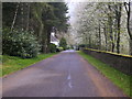
This page details the photographs taken nearby to DG2 0UA by members of the Geograph project.
The Geograph project started in 2005 with the aim of publishing, organising and preserving representative images for every square kilometre of Great Britain, Ireland and the Isle of Man.

There are currently over 7.5m images from over14,400 individuals and you can help contribute to the project by visiting https://www.geograph.org.uk
Image Map
Images are licensed for reuse under creativecommons.org/licenses/by-sa/2.0
Notes
- Clicking on the map will re-center to the selected point.
- The higher the marker number, the further away the image location is from the centre of the postcode.
Image Listing (5 Images Found)
Images are licensed for reuse under creativecommons.org/licenses/by-sa/2.0
Image
Details
Distance
2
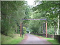
Entrance to Blackwood House
This sign I think is not original to this site. Thistle Brewery was at one time in Alloa, if anyone knows the history to this sign being here please add a comment.
Image: © derek menzies
Taken: 8 Aug 2008
0.16 miles
5
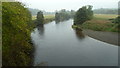
River Nith from Auldgirth Bridge
Looking upstream.
Image: © Peter Bond
Taken: 8 Oct 2011
0.25 miles