IMAGES TAKEN NEAR TO
Auldgirth, DUMFRIES, DG2 0TP
Introduction
This page details the photographs taken nearby to DG2 0TP by members of the Geograph project.
The Geograph project started in 2005 with the aim of publishing, organising and preserving representative images for every square kilometre of Great Britain, Ireland and the Isle of Man.

There are currently over 7.5m images from over14,400 individuals and you can help contribute to the project by visiting https://www.geograph.org.uk
Image Map
Images are licensed for reuse under creativecommons.org/licenses/by-sa/2.0
Notes
- Clicking on the map will re-center to the selected point.
- The higher the marker number, the further away the image location is from the centre of the postcode.
Image Listing (8 Images Found)
Images are licensed for reuse under creativecommons.org/licenses/by-sa/2.0
Image
Details
Distance
1
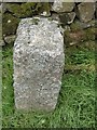
Old Milestone near Barndennoch, Keir parish
Stone post by the UC road, in parish of Keir (Nithsdale District), North of entrance to Barndennoch, on verge near wall, East side of road.
Inscription once read:-
(Dumfries)
(10)
Surveyed
Milestone Society National ID: DG_DFSQUC10
Image: © Milestone Society
Taken: Unknown
0.01 miles
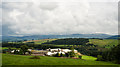
8
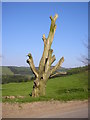
Dead tree on the Glenmidge road
The River Nith runs between the field and the skyline ridge.
Image: © Sue King-Smith
Taken: 24 Apr 2005
0.20 miles