IMAGES TAKEN NEAR TO
Auldgirth, DUMFRIES, DG2 0TN
Introduction
This page details the photographs taken nearby to DG2 0TN by members of the Geograph project.
The Geograph project started in 2005 with the aim of publishing, organising and preserving representative images for every square kilometre of Great Britain, Ireland and the Isle of Man.

There are currently over 7.5m images from over14,400 individuals and you can help contribute to the project by visiting https://www.geograph.org.uk
Image Map
Images are licensed for reuse under creativecommons.org/licenses/by-sa/2.0
Notes
- Clicking on the map will re-center to the selected point.
- The higher the marker number, the further away the image location is from the centre of the postcode.
Image Listing (5 Images Found)
Images are licensed for reuse under creativecommons.org/licenses/by-sa/2.0
Image
Details
Distance
1
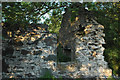
Another part of the ruined cottage.
Image: © Andrya Prescott
Taken: 19 Jul 2006
0.02 miles
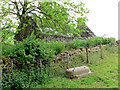
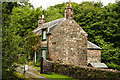
2
Ruined cottage
There was a parade of pheasants that ran before I could get my camera on the property. A lot of rustling in the tall grass ensued.
Image: © Andrya Prescott
Taken: 19 Jul 2006
0.06 miles
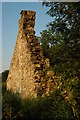
3
Ruined cottage
That must have been some bath night!
Image: © RH Dengate
Taken: 7 Jun 2007
0.11 miles
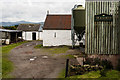
5
An estate cottage
An entrance and cottage at Barjarg
Image: © Hugh Close
Taken: 9 Sep 2013
0.21 miles