IMAGES TAKEN NEAR TO
Croftmaggot Road, DUMFRIES, DG2 0SB
Introduction
This page details the photographs taken nearby to Croftmaggot Road, DG2 0SB by members of the Geograph project.
The Geograph project started in 2005 with the aim of publishing, organising and preserving representative images for every square kilometre of Great Britain, Ireland and the Isle of Man.

There are currently over 7.5m images from over14,400 individuals and you can help contribute to the project by visiting https://www.geograph.org.uk
Image Map
Images are licensed for reuse under creativecommons.org/licenses/by-sa/2.0
Notes
- Clicking on the map will re-center to the selected point.
- The higher the marker number, the further away the image location is from the centre of the postcode.
Image Listing (9 Images Found)
Images are licensed for reuse under creativecommons.org/licenses/by-sa/2.0
Image
Details
Distance
1
Roller, Upper Portrack
A roller at the road end.
Image: © Richard Webb
Taken: 3 Sep 2015
0.04 miles
7
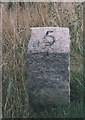
Old Milestone by the A76, near Glengower, Holywood parish
Granite post by the A76, in parish of Holywood (Nithsdale District), near junction to Irongray, on verge, West side of road.
Inscription reads:-
5
(To Dumfries)
Carved bench mark and rivet on top.
Surveyed
Milestone Society National ID: DG_DFCM05
Image: © Milestone Society
Taken: Unknown
0.21 miles
8
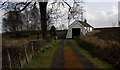
Charlesfield
The traditional cottage of Charlesfield.
Image: © Colin Kinnear
Taken: 26 Mar 2009
0.24 miles
9
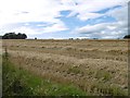
Newly cut barley
Near Williamsfield, Dumfriesshire
Image: © Richard Webb
Taken: 3 Sep 2015
0.25 miles