IMAGES TAKEN NEAR TO
Holywood, DUMFRIES, DG2 0RH
Introduction
This page details the photographs taken nearby to DG2 0RH by members of the Geograph project.
The Geograph project started in 2005 with the aim of publishing, organising and preserving representative images for every square kilometre of Great Britain, Ireland and the Isle of Man.

There are currently over 7.5m images from over14,400 individuals and you can help contribute to the project by visiting https://www.geograph.org.uk
Image Map
Images are licensed for reuse under creativecommons.org/licenses/by-sa/2.0
Notes
- Clicking on the map will re-center to the selected point.
- The higher the marker number, the further away the image location is from the centre of the postcode.
Image Listing (34 Images Found)
Images are licensed for reuse under creativecommons.org/licenses/by-sa/2.0
Image
Details
Distance
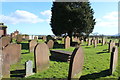
3
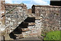
Stone Steps over the Wall
To Holywood Cemetery.
Image: © Billy McCrorie
Taken: 2 Apr 2017
0.07 miles
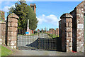
5
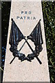
War Memorial, Holywood Churchyard
Pro Patria: For one's Country.
Image: © Billy McCrorie
Taken: 2 Apr 2017
0.08 miles
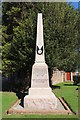
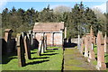
9
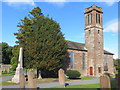
Holywood Church
Viewed from the south-west.
Image: © Peter Wood
Taken: 24 Sep 2014
0.09 miles
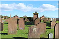
10
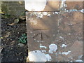
Ordnance Survey Cut Mark
This can be found on the wall of Holywood Church at Kirkland
For more detail see : http://www.bench-marks.org.uk/bm62469
Image: © Peter Wood
Taken: 24 Sep 2014
0.09 miles