IMAGES TAKEN NEAR TO
Old School Cottages, DUMFRIES, DG2 0RD
Introduction
This page details the photographs taken nearby to Old School Cottages, DG2 0RD by members of the Geograph project.
The Geograph project started in 2005 with the aim of publishing, organising and preserving representative images for every square kilometre of Great Britain, Ireland and the Isle of Man.

There are currently over 7.5m images from over14,400 individuals and you can help contribute to the project by visiting https://www.geograph.org.uk
Image Map
Images are licensed for reuse under creativecommons.org/licenses/by-sa/2.0
Notes
- Clicking on the map will re-center to the selected point.
- The higher the marker number, the further away the image location is from the centre of the postcode.
Image Listing (14 Images Found)
Images are licensed for reuse under creativecommons.org/licenses/by-sa/2.0
Image
Details
Distance
1
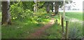
Woodland path near Holywood
Not shown on the map a good path near the village of Holywood.
Image: © Colin Kinnear
Taken: 16 Jun 2020
0.04 miles
9
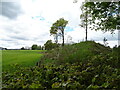
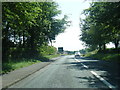
Disused railway embankment beside the A76
The former Dumfries and Moniaive Railway. It was opened in 1905 and was closed to passengers in 1943.
Image: © JThomas
Taken: 22 May 2021
0.24 miles