IMAGES TAKEN NEAR TO
Fergus Walk, DUMFRIES, DG2 0QN
Introduction
This page details the photographs taken nearby to Fergus Walk, DG2 0QN by members of the Geograph project.
The Geograph project started in 2005 with the aim of publishing, organising and preserving representative images for every square kilometre of Great Britain, Ireland and the Isle of Man.

There are currently over 7.5m images from over14,400 individuals and you can help contribute to the project by visiting https://www.geograph.org.uk
Image Map
Images are licensed for reuse under creativecommons.org/licenses/by-sa/2.0
Notes
- Clicking on the map will re-center to the selected point.
- The higher the marker number, the further away the image location is from the centre of the postcode.
Image Listing (70 Images Found)
Images are licensed for reuse under creativecommons.org/licenses/by-sa/2.0
Image
Details
Distance
1
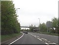
Foot Bridge
Bridge over the A75 at Dumfries taken from a car travelling east
Image: © David Wild
Taken: 17 Sep 2005
0.02 miles
3
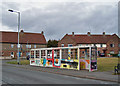
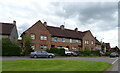
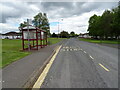
Long wait for buses?
This decorated bus shelter is more than double the usual length. It stands in College Road in the Lincluden estate. Behind are houses in College Drive.
Image: © Richard Dorrell
Taken: 19 Mar 2010
0.06 miles
4
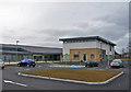
Lincluden primary school
The new school in Priory Road was completed in November 2009 at a cost of £5.6 million. It has ten classrooms, and a roll of about 260 children including 45 in the nursery department. The new school was built adjacent to the existing primary school which remained operational throughout. Upon completion of the new building, the old school was demolished, and new external play areas and a multi-use games facilities created.
Image: © Richard Dorrell
Taken: 19 Mar 2010
0.09 miles
5
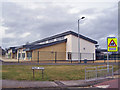
Lincluden primary school
The new school in Priory Road was completed in November 2009 at a cost of £5.6 million. It has ten classrooms, and a roll of about 260 children including 45 in the nursery department. The new school was built adjacent to the existing primary school which remained operational throughout. Upon completion of the new building, the old school was demolished, and new external play areas and a multi-use games facilities created.
Image: © Richard Dorrell
Taken: 19 Mar 2010
0.11 miles
6
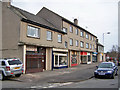
Lincluden shops
This parade of shops with flats above in Lincluden Road serve the large Lincluden housing estate.
Image: © Richard Dorrell
Taken: 19 Mar 2010
0.12 miles
7
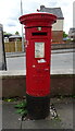
George V postbox on Lincluden Road, Dumfries
Postbox No. DG2 61.
See Image] for context.
Image: © JThomas
Taken: 22 May 2021
0.13 miles
8
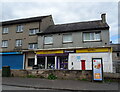
Lincluden Superstore on Lincluden Road, Dumfries
Showing position of Postbox No. DG2 61.
See Image] for postbox.
Image: © JThomas
Taken: 22 May 2021
0.13 miles