IMAGES TAKEN NEAR TO
DUMFRIES, DG2 0JQ
Introduction
This page details the photographs taken nearby to DG2 0JQ by members of the Geograph project.
The Geograph project started in 2005 with the aim of publishing, organising and preserving representative images for every square kilometre of Great Britain, Ireland and the Isle of Man.

There are currently over 7.5m images from over14,400 individuals and you can help contribute to the project by visiting https://www.geograph.org.uk
Image Map
Images are licensed for reuse under creativecommons.org/licenses/by-sa/2.0
Notes
- Clicking on the map will re-center to the selected point.
- The higher the marker number, the further away the image location is from the centre of the postcode.
Image Listing (5 Images Found)
Images are licensed for reuse under creativecommons.org/licenses/by-sa/2.0
Image
Details
Distance
1
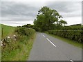
B729, Greenhead
After a visit from the hedge trimmer. I got away with it this time - no punctures.
Image: © Richard Webb
Taken: 3 Sep 2015
0.15 miles
2
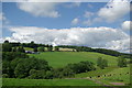
Farmland below Greenhead
View towards the farm of Townhead
Image: © Leslie Barrie
Taken: 2 Jul 2011
0.16 miles
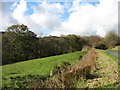
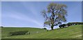
4
Pasture field and tree
To the northeast of Townfoot Farm.
Image: © Walter Baxter
Taken: 31 Mar 2007
0.24 miles
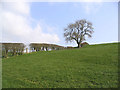
5
Blue on Green
Recently cut fields on a sunny afternoon.
Image: © Colin Kinnear
Taken: 28 May 2020
0.24 miles