IMAGES TAKEN NEAR TO
Lochside Road, DUMFRIES, DG2 0EA
Introduction
This page details the photographs taken nearby to Lochside Road, DG2 0EA by members of the Geograph project.
The Geograph project started in 2005 with the aim of publishing, organising and preserving representative images for every square kilometre of Great Britain, Ireland and the Isle of Man.

There are currently over 7.5m images from over14,400 individuals and you can help contribute to the project by visiting https://www.geograph.org.uk
Image Map
Images are licensed for reuse under creativecommons.org/licenses/by-sa/2.0
Notes
- Clicking on the map will re-center to the selected point.
- The higher the marker number, the further away the image location is from the centre of the postcode.
Image Listing (8 Images Found)
Images are licensed for reuse under creativecommons.org/licenses/by-sa/2.0
Image
Details
Distance
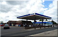
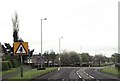
3
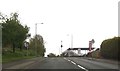
Garage at start of 30 mph limit
A76 entering Dumfries
Image: © John Firth
Taken: 19 May 2013
0.20 miles
4
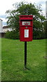
Elizabethan postbox on Newbridge Drive, Dumfries
Postbox No. DG2 208.
See Image] for context.
Image: © JThomas
Taken: 22 May 2021
0.20 miles
5
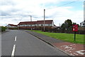
Newbridge Drive, Dumfries
Showing position of Postbox No. DG2 208.
See Image] for postbox.
Image: © JThomas
Taken: 22 May 2021
0.20 miles
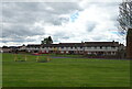
6
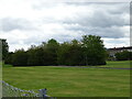
Green space and woodland near housing estate
Image: © JThomas
Taken: 22 May 2021
0.21 miles