IMAGES TAKEN NEAR TO
Cairn Avenue, DUMFRIES, DG2 0DF
Introduction
This page details the photographs taken nearby to Cairn Avenue, DG2 0DF by members of the Geograph project.
The Geograph project started in 2005 with the aim of publishing, organising and preserving representative images for every square kilometre of Great Britain, Ireland and the Isle of Man.

There are currently over 7.5m images from over14,400 individuals and you can help contribute to the project by visiting https://www.geograph.org.uk
Image Map
Images are licensed for reuse under creativecommons.org/licenses/by-sa/2.0
Notes
- Clicking on the map will re-center to the selected point.
- The higher the marker number, the further away the image location is from the centre of the postcode.
Image Listing (61 Images Found)
Images are licensed for reuse under creativecommons.org/licenses/by-sa/2.0
Image
Details
Distance
2
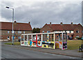
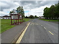
Long wait for buses?
This decorated bus shelter is more than double the usual length. It stands in College Road in the Lincluden estate. Behind are houses in College Drive.
Image: © Richard Dorrell
Taken: 19 Mar 2010
0.08 miles
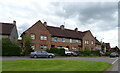
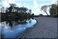
4
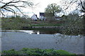
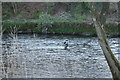
River Nith
Houses on College Avenue.
Image: © Billy McCrorie
Taken: 17 Apr 2017
0.10 miles
5
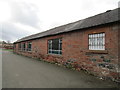
Farm buildings, Abbey Farm, Lincluden
Image: © Jonathan Thacker
Taken: 22 Feb 2020
0.11 miles
7
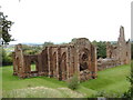
Ruins of Lincluden Collegiate Church
Image: © Darrin Antrobus
Taken: 27 Aug 2007
0.12 miles