IMAGES TAKEN NEAR TO
Forsyth Street, DUMFRIES, DG2 0BE
Introduction
This page details the photographs taken nearby to Forsyth Street, DG2 0BE by members of the Geograph project.
The Geograph project started in 2005 with the aim of publishing, organising and preserving representative images for every square kilometre of Great Britain, Ireland and the Isle of Man.

There are currently over 7.5m images from over14,400 individuals and you can help contribute to the project by visiting https://www.geograph.org.uk
Image Map
Images are licensed for reuse under creativecommons.org/licenses/by-sa/2.0
Notes
- Clicking on the map will re-center to the selected point.
- The higher the marker number, the further away the image location is from the centre of the postcode.
Image Listing (20 Images Found)
Images are licensed for reuse under creativecommons.org/licenses/by-sa/2.0
Image
Details
Distance

2
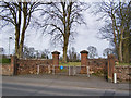
Goldie Park gates
The original gates have been removed and replaced with a rather ugly pedestrian barrier. The left hand gate pillar bears the carved inscription "Goldie Public Park 1904". This entrance is from the Glasgow Street.
Image: © Richard Dorrell
Taken: 19 Mar 2010
0.14 miles
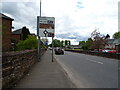
5

The Bridge
New college building in Dumfries.
Image: © Richard Webb
Taken: 22 Apr 2019
0.19 miles
6
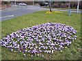
Council crocuses
Large colourful mats of crocus flowers decorate the traffic islands in Glasgow Street, Dumfries. This is the roundabout junction with Sunderries Road (on the left).
Image: © Richard Dorrell
Taken: 19 Mar 2010
0.19 miles
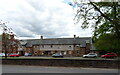
7
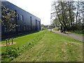
Beside The Bridge
A newly built vocational education centre in Dumfries.
Image: © Richard Webb
Taken: 22 Apr 2019
0.20 miles
8
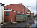
BPI Polythene
This is the rear of the plant which is alongside the Maxwelltown Path. The path follows the line of the now dismantled Dumfries to Stranraer railway. BPI is one of the leading manufacturers of polythene products, supplying over 300,000 tonnes each year for a wide variety of everyday applications and recycling and reprocessing over 70,000 tonnes of UK waste from industrial, commercial, agricultural and domestic sources. BPI website - http://www.bpipoly.com/ .
Image: © Richard Dorrell
Taken: 19 Mar 2010
0.20 miles
9
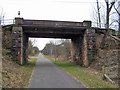
Railway bridge without a railway
The bridge no longer carries traffic over it or sees trains under it. It provides pedestrian and cycle access over the top between College Road and College Mains Road, and beneath is the Maxwelltown Path - a cycle and foot way running along the route of the Dumfries to Stranraer railway which was dismantled in 2005.
Image: © Richard Dorrell
Taken: 19 Mar 2010
0.21 miles
10
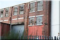
Old Nestle Factory
Nestle withdrew from Dumfries December 2000. Factory site has been taken over by Dunlop's, but some areas lack maintenance
Image: © Anne Barclay
Taken: 8 Dec 2011
0.22 miles