IMAGES TAKEN NEAR TO
Makbrars Neuk, DUMFRIES, DG1 4XB
Introduction
This page details the photographs taken nearby to Makbrars Neuk, DG1 4XB by members of the Geograph project.
The Geograph project started in 2005 with the aim of publishing, organising and preserving representative images for every square kilometre of Great Britain, Ireland and the Isle of Man.

There are currently over 7.5m images from over14,400 individuals and you can help contribute to the project by visiting https://www.geograph.org.uk
Image Map (Loading...)


Getting Data...Please wait
Leaflet Map data © OpenStreetMap
Images are licensed for reuse under creativecommons.org/licenses/by-sa/2.0
Notes
- Clicking on the map will re-center to the selected point.
- The higher the marker number, the further away the image location is from the centre of the postcode.
Image Listing (6 Images Found)
Images are licensed for reuse under creativecommons.org/licenses/by-sa/2.0
Image
Details
Distance
1
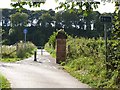
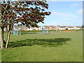
Maidenbower Cycle Path
Dumfries town is well provided with cycle paths. This circumferential path links Craig Road with Bankend Road. What appears to be a single old gate post stands to the right.
Image: © Oliver Dixon
Taken: 2 Sep 2013
0.14 miles
5
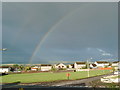
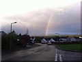
Rainbow over Dumfries
View of a common area on Rowanbank Road in the Georgetown area of Dumfries.
Image: © Darrin Antrobus
Taken: 26 Jul 2007
0.22 miles