IMAGES TAKEN NEAR TO
Racks, DUMFRIES, DG1 4PU
Introduction
This page details the photographs taken nearby to DG1 4PU by members of the Geograph project.
The Geograph project started in 2005 with the aim of publishing, organising and preserving representative images for every square kilometre of Great Britain, Ireland and the Isle of Man.

There are currently over 7.5m images from over14,400 individuals and you can help contribute to the project by visiting https://www.geograph.org.uk
Image Map
Images are licensed for reuse under creativecommons.org/licenses/by-sa/2.0
Notes
- Clicking on the map will re-center to the selected point.
- The higher the marker number, the further away the image location is from the centre of the postcode.
Image Listing (6 Images Found)
Images are licensed for reuse under creativecommons.org/licenses/by-sa/2.0
Image
Details
Distance
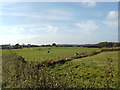
1
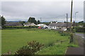
Racks
The eastern end of the hamlet of Racks.
Image: © Colin Kinnear
Taken: 4 Jul 2020
0.04 miles
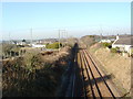
4
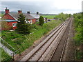
Racks railway station (site), Dumfries & Galloway
Opened in 1848 by the Glasgow Dumfries & Carlisle Railway, soon to become part of the Glasgow & South Western Railway, this station closed in 1965.
View south east towards Ruthwell and Carlisle.
Image: © Nigel Thompson
Taken: 7 May 2019
0.18 miles
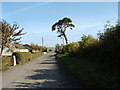
6
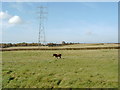
Lone horse under power lines near Racks
Image: © Darrin Antrobus
Taken: 10 Oct 2007
0.24 miles