IMAGES TAKEN NEAR TO
CANONBIE, DG14 0TP
Introduction
This page details the photographs taken nearby to DG14 0TP by members of the Geograph project.
The Geograph project started in 2005 with the aim of publishing, organising and preserving representative images for every square kilometre of Great Britain, Ireland and the Isle of Man.

There are currently over 7.5m images from over14,400 individuals and you can help contribute to the project by visiting https://www.geograph.org.uk
Image Map (Loading...)


Getting Data...Please wait
Leaflet Map data © OpenStreetMap
Images are licensed for reuse under creativecommons.org/licenses/by-sa/2.0
Notes
- Clicking on the map will re-center to the selected point.
- The higher the marker number, the further away the image location is from the centre of the postcode.
Image Listing (5 Images Found)
Images are licensed for reuse under creativecommons.org/licenses/by-sa/2.0
Image
Details
Distance
1
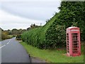
Telephone box at Milltown
An old-style telephone box, alongside a large cypress hedge, flanking the B6357.
Image: © Oliver Dixon
Taken: 19 Oct 2010
0.09 miles
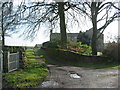
4
Tower-of-Sark grave yard
Kinmont Willie is buried here.
Image: © Howard Mattinson
Taken: 17 Feb 2007
0.23 miles
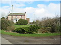
5

Tower-of-Sark Farm
Viewed from the old graveyard on the west side of the farm.
Image: © Walter Baxter
Taken: 23 Nov 2010
0.25 miles