IMAGES TAKEN NEAR TO
Dinwiddie Drive, DUMFRIES, DG1 3SN
Introduction
This page details the photographs taken nearby to Dinwiddie Drive, DG1 3SN by members of the Geograph project.
The Geograph project started in 2005 with the aim of publishing, organising and preserving representative images for every square kilometre of Great Britain, Ireland and the Isle of Man.

There are currently over 7.5m images from over14,400 individuals and you can help contribute to the project by visiting https://www.geograph.org.uk
Image Map
Images are licensed for reuse under creativecommons.org/licenses/by-sa/2.0
Notes
- Clicking on the map will re-center to the selected point.
- The higher the marker number, the further away the image location is from the centre of the postcode.
Image Listing (6 Images Found)
Images are licensed for reuse under creativecommons.org/licenses/by-sa/2.0
Image
Details
Distance
2
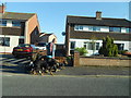
Anne Arundal Court
Entrance to Anne Arundal Court.
Image: © Colin Kinnear
Taken: 26 Jun 2008
0.17 miles
3
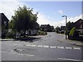
Off Downs Way, Heathhall
Suburban Dumfries.
Image: © Richard Webb
Taken: 22 Apr 2019
0.22 miles
4
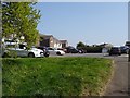
Dumfries and Galloway College
The main campus building is at Heathhall, located in the outskirts of Dumfries. It was officially opened in September 1973 by HRH Princess Alexandra.
Image: © Darrin Antrobus
Taken: 5 Jun 2007
0.23 miles
5
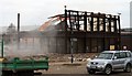
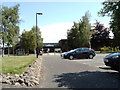
Demolition Day
The last parts of Dumfries Tech College being demolished.
Image: © Colin Kinnear
Taken: 17 Mar 2009
0.24 miles
6
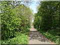
Cycle path between Locharbriggs and Dumfries
On the trackbed of the Dumfries, Lochmaben and Lockerbie Railway.
Image: © Richard Webb
Taken: 22 Apr 2019
0.24 miles