IMAGES TAKEN NEAR TO
Tinwald, DUMFRIES, DG1 3PL
Introduction
This page details the photographs taken nearby to DG1 3PL by members of the Geograph project.
The Geograph project started in 2005 with the aim of publishing, organising and preserving representative images for every square kilometre of Great Britain, Ireland and the Isle of Man.

There are currently over 7.5m images from over14,400 individuals and you can help contribute to the project by visiting https://www.geograph.org.uk
Image Map
Images are licensed for reuse under creativecommons.org/licenses/by-sa/2.0
Notes
- Clicking on the map will re-center to the selected point.
- The higher the marker number, the further away the image location is from the centre of the postcode.
Image Listing (14 Images Found)
Images are licensed for reuse under creativecommons.org/licenses/by-sa/2.0
Image
Details
Distance
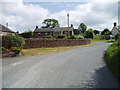
1
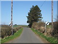
Minor road heading out of Tinwald
In Dumfries and Galloway.
Image: © James Denham
Taken: 14 Apr 2010
0.04 miles
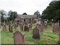
2
Tinwald Kirk
Tinwald has a colourful history. Like many others, the rector of the Roman Catholic church suddenly became Protestant at the Scottish Reformation in 1560 and retained his charge. Another wonderful story is of 21 years old, Alexander Robeson of Kelso who was elected to serve as minister in the late 17th. century but Alexander did not wish to be minister and left. He was chased, restrained and return to the church where he later spent 65 years in his ministry until he died in 1721, aged 86.
Image: © James Denham
Taken: 14 Apr 2010
0.05 miles
4
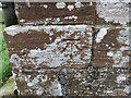
Ordnance Survey Cut Mark
This mark can be found on the wall (east end) of Tinwald Parish Church.
The recorded details give a height of 53.8452 metres above sea level.
For more detail see : https://www.bench-marks.org.uk/bm179911
Image: © Peter Wood
Taken: 30 Sep 2024
0.07 miles
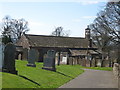
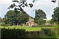
5
Tinwald Parish Church and part of its burial ground
Viewed from the northeast.
Image: © Peter Wood
Taken: 30 Sep 2024
0.07 miles
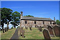
6
Tinwald Kirk
The sandstone towers with the stone ball on top are something of a Dumfriesshire trademark.
Image: © Richard Webb
Taken: 17 Aug 2015
0.08 miles
7
Tinwald Parish Church
A plain rectangle with bell-finialled birdcage bellcote built in 1769 on the foundations of an earlier medieval church. Four stained glass windows by Gordon Webster. Interior, with fine hammerbeam roof, has the matching pews arranged to form a central aisle. Chancel area furnished in oak with octagonal pulpit, pedestal font, communion table and Minister’s and Elders’ chairs. Session Room added 2000. Covenanters’ Monument in graveyard.
Image: © Colin Kinnear
Taken: 27 May 2020
0.08 miles
8
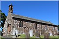
Tinwald Parish Church
Category B-listed. Built 1765 on earlier foundations. Alterations and additions made late 19th century.
Image: © Leslie Barrie
Taken: 11 Jun 2015
0.08 miles
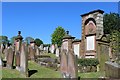
9
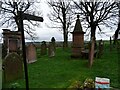
Covenanter's Monument
Covenanter's Monument in Tinwald graveyard.
Image: © Rab McMurdo
Taken: 25 Mar 2023
0.08 miles
10
Tinwald
A small scattered village overlooking Nithsdale. It was in this village that the founder of the Bank of England William Paterson was born in 1658.
Image: © Kevin Rae
Taken: 28 Jul 2006
0.10 miles