IMAGES TAKEN NEAR TO
Amisfield, DUMFRIES, DG1 3PB
Introduction
This page details the photographs taken nearby to DG1 3PB by members of the Geograph project.
The Geograph project started in 2005 with the aim of publishing, organising and preserving representative images for every square kilometre of Great Britain, Ireland and the Isle of Man.

There are currently over 7.5m images from over14,400 individuals and you can help contribute to the project by visiting https://www.geograph.org.uk
Image Map
Images are licensed for reuse under creativecommons.org/licenses/by-sa/2.0
Notes
- Clicking on the map will re-center to the selected point.
- The higher the marker number, the further away the image location is from the centre of the postcode.
Image Listing (4 Images Found)
Images are licensed for reuse under creativecommons.org/licenses/by-sa/2.0
Image
Details
Distance
1
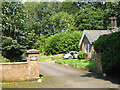
Lodge and gateway to Amisfield Tower
Amisfield Tower is a 17th century tower house, regarded by some as the finest tower house in southern Scotland. Occupied as a private residence. No images on Geograph as yet.
Image: © Oliver Dixon
Taken: 23 Aug 2015
0.18 miles
2
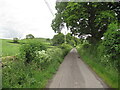
The turning for Hazelrig
South of Amisfield Tower.
Image: © Russel Wills
Taken: 29 Sep 2021
0.19 miles