IMAGES TAKEN NEAR TO
Brownrigg Loaning, DUMFRIES, DG1 3JS
Introduction
This page details the photographs taken nearby to Brownrigg Loaning, DG1 3JS by members of the Geograph project.
The Geograph project started in 2005 with the aim of publishing, organising and preserving representative images for every square kilometre of Great Britain, Ireland and the Isle of Man.

There are currently over 7.5m images from over14,400 individuals and you can help contribute to the project by visiting https://www.geograph.org.uk
Image Map (Loading...)


Getting Data...Please wait
Leaflet Map data © OpenStreetMap
Images are licensed for reuse under creativecommons.org/licenses/by-sa/2.0
Notes
- Clicking on the map will re-center to the selected point.
- The higher the marker number, the further away the image location is from the centre of the postcode.
Image Listing (12 Images Found)
Images are licensed for reuse under creativecommons.org/licenses/by-sa/2.0
Image
Details
Distance
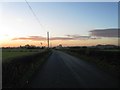
1
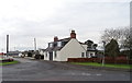
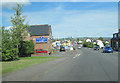
Annan Road, Gasstown
The main eastwards route in or out of Dumfries.
Image: © Richard Webb
Taken: 31 Jul 2024
0.14 miles
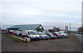
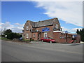
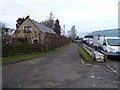
3
Annan road through Gasstown
Five Arches public house to left
Image: © John Firth
Taken: 9 May 2012
0.19 miles
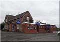
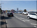
6
Annan Road, Dumfries
The A780, to the east of Dumfries.
Image: © David Dixon
Taken: 14 Feb 2013
0.22 miles
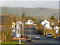
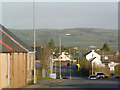
8
Road to Floshknowe
Off Annan Road (A780), Dumfries.
Image: © JThomas
Taken: 19 Nov 2019
0.22 miles