IMAGES TAKEN NEAR TO
Eskdalemuir, LANGHOLM, DG13 0QW
Introduction
This page details the photographs taken nearby to DG13 0QW by members of the Geograph project.
The Geograph project started in 2005 with the aim of publishing, organising and preserving representative images for every square kilometre of Great Britain, Ireland and the Isle of Man.

There are currently over 7.5m images from over14,400 individuals and you can help contribute to the project by visiting https://www.geograph.org.uk
Image Map (Loading...)


Getting Data...Please wait
Leaflet Map data © OpenStreetMap
Images are licensed for reuse under creativecommons.org/licenses/by-sa/2.0
Notes
- Clicking on the map will re-center to the selected point.
- The higher the marker number, the further away the image location is from the centre of the postcode.
Image Listing (10 Images Found)
Images are licensed for reuse under creativecommons.org/licenses/by-sa/2.0
Image
Details
Distance
1
Davington Burn
Looking upstream from the bridge on the B709.
Image: © Oliver Dixon
Taken: 15 Oct 2018
0.03 miles
2
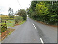
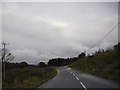
Road (B709) near to Davington
Looking northward towards a bridge crossing Davington Burn.
Image: © Peter Wood
Taken: 30 Sep 2021
0.03 miles

4
View from Eskdalemuir Observatory to the south
Image: © Andrew King
Taken: 31 Aug 2012
0.11 miles
5
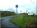
The road to the Observatory
Eskdalemuir Observatory is operated by the British Geological Survey - see other photo in the square.
Image: © David Medcalf
Taken: 20 Aug 2006
0.15 miles
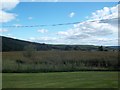
6
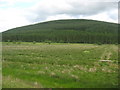
Rough grazing near Davington in Dumfries and Galloway
With forest beyond.
Image: © James Denham
Taken: 3 Jul 2010
0.15 miles
7
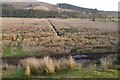
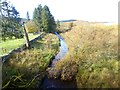
Wet pasture, Davington
Ditch and rashy land beside the White Esk.
Image: © Richard Webb
Taken: 13 Jan 2019
0.17 miles

10

Eskdalemuir Observatory
This Observatory was founded here in 1908 and is operated by The British Geological Survey and The Met. Office. The centre is involved in monitoring changes in the United Kingdom's natural geomagnetic field and is also involved in earthquake detection and weather forecasting. The observatory is not opened to the public and this photograph was taken from just outside the entrance.
Image: © Kevin Rae
Taken: 24 Jul 2006
0.25 miles