IMAGES TAKEN NEAR TO
Eskdalemuir, LANGHOLM, DG13 0QP
Introduction
This page details the photographs taken nearby to DG13 0QP by members of the Geograph project.
The Geograph project started in 2005 with the aim of publishing, organising and preserving representative images for every square kilometre of Great Britain, Ireland and the Isle of Man.

There are currently over 7.5m images from over14,400 individuals and you can help contribute to the project by visiting https://www.geograph.org.uk
Image Map (Loading...)


Getting Data...Please wait
Leaflet Map data © OpenStreetMap
Images are licensed for reuse under creativecommons.org/licenses/by-sa/2.0
Notes
- Clicking on the map will re-center to the selected point.
- The higher the marker number, the further away the image location is from the centre of the postcode.
Image Listing (7 Images Found)
Images are licensed for reuse under creativecommons.org/licenses/by-sa/2.0
Image
Details
Distance
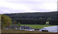
2
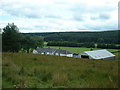
Fingland Farm
Over Cassock Farm can be seen on the far side of the river.
Image: © Oliver Dixon
Taken: 15 Oct 2018
0.01 miles
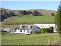
5
Fingland farm
Looking south, over the valley of the White Esk.
Image: © David Medcalf
Taken: 20 Aug 2006
0.08 miles
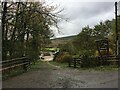
6
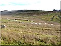
Sheep on rough grazing
On the slopes of Watch Craig.
Image: © Oliver Dixon
Taken: 15 Oct 2018
0.16 miles
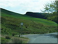
7

Hill pasture, Eskdale
Above the B709 on Watch Craig.
Image: © Richard Webb
Taken: 18 Nov 2018
0.24 miles