IMAGES TAKEN NEAR TO
LANGHOLM, DG13 0PR
Introduction
This page details the photographs taken nearby to DG13 0PR by members of the Geograph project.
The Geograph project started in 2005 with the aim of publishing, organising and preserving representative images for every square kilometre of Great Britain, Ireland and the Isle of Man.

There are currently over 7.5m images from over14,400 individuals and you can help contribute to the project by visiting https://www.geograph.org.uk
Image Map (Loading...)


Getting Data...Please wait
Leaflet Map data © OpenStreetMap
Images are licensed for reuse under creativecommons.org/licenses/by-sa/2.0
Notes
- Clicking on the map will re-center to the selected point.
- The higher the marker number, the further away the image location is from the centre of the postcode.
Image Listing (47 Images Found)
Images are licensed for reuse under creativecommons.org/licenses/by-sa/2.0
Image
Details
Distance
1
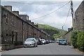
Eskdaill Street, Langholm
Terraced houses in New Langholm.
Image: © Jim Barton
Taken: 17 Jun 2019
0.08 miles
3
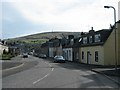
Caroline Street, Langholm
Only the houses on the right hand side of the street are on Caroline Street, the other side is Beucleuch Terrace.
Image: © Chris Ward
Taken: 15 Apr 2006
0.14 miles
4
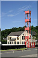
The drill tower at Langholm Fire Station
At the edge of the square in Albert Place.
Image: © Walter Baxter
Taken: 20 Jun 2010
0.17 miles
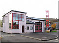
5
Langholm Fire Station
At the edge of the square in Albert Place.
Image: © Walter Baxter
Taken: 20 Jun 2010
0.18 miles
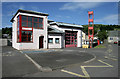
6
Langholm Fire Station
Located in Albert Place at the edge of the square.
Image: © Walter Baxter
Taken: 3 Nov 2007
0.18 miles
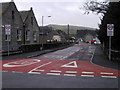
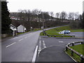
7
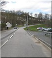
Nearly in Langholm
The B709, passing the school is nearly in the town centre.
Image: © James Denham
Taken: 20 Apr 2010
0.19 miles
10

The clubhouse at Langholm Bowling Club
This small clubhouse with a date of 1898 above the door is at the west end of the green. A grid line runs through the building.
Image: © Walter Baxter
Taken: 20 Jun 2010
0.19 miles