IMAGES TAKEN NEAR TO
Westerkirk, LANGHOLM, DG13 0NN
Introduction
This page details the photographs taken nearby to DG13 0NN by members of the Geograph project.
The Geograph project started in 2005 with the aim of publishing, organising and preserving representative images for every square kilometre of Great Britain, Ireland and the Isle of Man.

There are currently over 7.5m images from over14,400 individuals and you can help contribute to the project by visiting https://www.geograph.org.uk
Image Map (Loading...)


Getting Data...Please wait
Leaflet Map data © OpenStreetMap
Images are licensed for reuse under creativecommons.org/licenses/by-sa/2.0
Notes
- Clicking on the map will re-center to the selected point.
- The higher the marker number, the further away the image location is from the centre of the postcode.
Image Listing (10 Images Found)
Images are licensed for reuse under creativecommons.org/licenses/by-sa/2.0
Image
Details
Distance
1
A house at Megdale
Viewed from the single track road to Glendinning.
Image: © Walter Baxter
Taken: 18 Feb 2007
0.01 miles
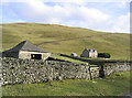
2
Megdale Farm
On the far side of the Meggat Water from the cul de sac road up to Glendinning. Crossing the stream by the footbridge in view is very definitely not recommended (see Image).
Image: © Oliver Dixon
Taken: 8 Aug 2015
0.05 miles
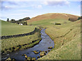
3
Meggat Water
Confluence of the Trough Hope burn and Meggat Water.
Image: © Richard Webb
Taken: 25 May 2010
0.06 miles
4
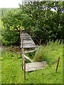
Dilapidated footbridge at Megdale
Surprisingly, access to this footbridge has not been blocked off, but it would be foolhardy indeed to attempt to cross the Meggat Water here, especially as there is a perfectly good Bailey bridge nearby.
Image: © Oliver Dixon
Taken: 8 Aug 2015
0.06 miles
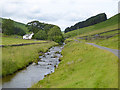
5
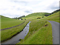
The Meggat Water
Looking upstream towards Megdale. The road is the cul-de-sac road to Glendinning.
Image: © Oliver Dixon
Taken: 8 Aug 2015
0.09 miles
6
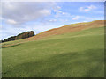
Hill pasture
A field on the lower southwest slopes of Alkin Hill with rough grazing and bracken higher up.
Image: © Walter Baxter
Taken: 18 Feb 2007
0.10 miles
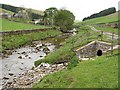
7
Bridges over the Meggat Water at Megdale
The further bridge is a Bailey bridge leading to Megdale Farm. The nearer bridge is a highly unsafe footbridge (see Image).
Image: © Oliver Dixon
Taken: 8 Aug 2015
0.10 miles
8
The Meggat Water south of Megdale
Alkin Hill is in the background.
Image: © Walter Baxter
Taken: 18 Feb 2007
0.18 miles
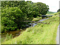
9
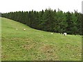
Sheep, Bught Knowe
Grazing beside the Meggat Water. The woodland surrounds Bught Sike a cleuch running down from Bught Knowe.
Image: © Richard Webb
Taken: 25 May 2010
0.22 miles
10
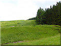
Hillside below Bught Knowe
The plantation to the right flanks Bught Sike.
Image: © Oliver Dixon
Taken: 8 Aug 2015
0.23 miles