IMAGES TAKEN NEAR TO
Westerkirk, LANGHOLM, DG13 0NG
Introduction
This page details the photographs taken nearby to DG13 0NG by members of the Geograph project.
The Geograph project started in 2005 with the aim of publishing, organising and preserving representative images for every square kilometre of Great Britain, Ireland and the Isle of Man.

There are currently over 7.5m images from over14,400 individuals and you can help contribute to the project by visiting https://www.geograph.org.uk
Image Map
Images are licensed for reuse under creativecommons.org/licenses/by-sa/2.0
Notes
- Clicking on the map will re-center to the selected point.
- The higher the marker number, the further away the image location is from the centre of the postcode.
Image Listing (7 Images Found)
Images are licensed for reuse under creativecommons.org/licenses/by-sa/2.0
Image
Details
Distance
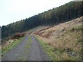
1
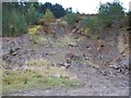
Track to Burnfoot Farm
In Dumfries and Galloway.
Image: © James Denham
Taken: 20 Apr 2010
0.04 miles
2
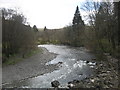
The River Esk near Burnfoot
In Dumfries and Galloway.
Image: © James Denham
Taken: 20 Apr 2010
0.07 miles
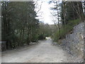
3
Burnfoot House
Large country house near Langholm.
Image: © Colin Kinnear
Taken: 19 Apr 2010
0.07 miles
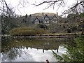
4
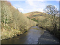
The River Esk
Viewed from the bridge at Burnfoot. Golf Hill is in the background.
Image: © Walter Baxter
Taken: 18 Feb 2007
0.10 miles
6
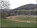
Langholm Racing
A five-and-a-half furlong sand gallop with six schooling fences; part of the James Ewart Racing establishment at Craig.
Image: © Oliver Dixon
Taken: 13 Apr 2009
0.20 miles