IMAGES TAKEN NEAR TO
LANGHOLM, DG13 0NF
Introduction
This page details the photographs taken nearby to DG13 0NF by members of the Geograph project.
The Geograph project started in 2005 with the aim of publishing, organising and preserving representative images for every square kilometre of Great Britain, Ireland and the Isle of Man.

There are currently over 7.5m images from over14,400 individuals and you can help contribute to the project by visiting https://www.geograph.org.uk
Image Map (Loading...)


Getting Data...Please wait
Leaflet Map data © OpenStreetMap
Images are licensed for reuse under creativecommons.org/licenses/by-sa/2.0
Notes
- Clicking on the map will re-center to the selected point.
- The higher the marker number, the further away the image location is from the centre of the postcode.
Image Listing (14 Images Found)
Images are licensed for reuse under creativecommons.org/licenses/by-sa/2.0
Image
Details
Distance
1
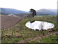
Pond at Henwell
The farm buildings at Staplegordon can be seen to the left. Clark Fell Image on the far side of the River Esk can be seen to the right.
Image: © Oliver Dixon
Taken: 13 Apr 2009
0.01 miles
2
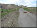
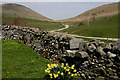
Road heading in to the Esk Valley
Near Staplegordon in Dumfries and Galloway.
Image: © James Denham
Taken: 20 Apr 2010
0.17 miles
3
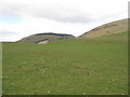
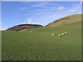
Grazing lands in Dumfries and Galloway
Near Craig and Staplegordon.
Image: © James Denham
Taken: 20 Apr 2010
0.17 miles
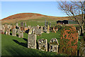
4
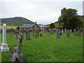
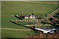
Staplegordon Old Churchyard
Former parish known as Staplegortoun, the church (C12) was transferred to Langholm in 1702 and fell into ruin. The churchyard has interesting C18 & C19 headstones with a C7-C8 cross-slab set in wall.
Image: © Chris Newman
Taken: 15 Aug 2005
0.18 miles
5
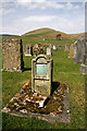
The east wall of Staplegordon Graveyard
Access to the graveyard can be made by stepping stones set into this wall. Bauchle Hill and Wrae Hill are in the background.
Image: © Walter Baxter
Taken: 24 Apr 2010
0.20 miles
6
Pasture
Viewed from the Burnfoot Road. The wooded hill is Dowglen Hill with Golf Hill on the right.
Image: © Walter Baxter
Taken: 18 Feb 2007
0.21 miles
7
Staplegordon Churchyard near Potholm Farm
A 12th century church on this site fell into ruins and the parish was transferred to nearby Langholm in the early 18th century. The graveyard, on the west side of Potholm Farm, has a good collection of 18th century symbolic stones. Viewed from the summit area of Clark Fell in the adjoining square to the southwest.
Image: © Walter Baxter
Taken: 30 Nov 2009
0.21 miles
8
Staplegordon Graveyard
A 12th century church on this site fell into ruins and the parish was transferred to nearby Langholm in the early 18th century. The graveyard, on the west side of Potholm Farm, has a good collection of 18th century symbolic stones. Golf Hill is in the background. The foreground gravestone has the following interesting inscription:-
THE GRAVE OF GEORGE
MAXWELL OF BROOMHOLM.
HE REQUESTS OF POSTERI-
TY THAT THEY WILL NOT
DISTURB HIS REMAINS NOR
THOSE OF HIS PARENTS
WHOSE GRAVES ARE NEXT
TO HIS ON THE EAST.
GOD BE MERCIFUL TO HIM
FOR CHRIST’S SAKE
Image: © Walter Baxter
Taken: 24 Apr 2010
0.21 miles
9
Staplegordon graveyard near Potholm
A 12th century church on this site fell into ruins and the parish was transferred to nearby Langholm in the early 18th century. The graveyard, on the west side of Potholm Farm, has a good collection of 18th century symbolic stones. Wrae Hill is in the background to the left.
Image: © Walter Baxter
Taken: 30 Nov 2009
0.22 miles
10
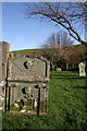
An old gravestone at Staplegordon Churchyard
This old graveyard on the west side of Potholm Farm contains many fine old symbolic 18th century headstones and table tombs. This one dated 1747, displays emblems of mortality on the lower half with a skull, bones and an hourglass. A winged soul above is an emblem of immortality depicting the human soul arising to await the Day of Judgement.
Image: © Walter Baxter
Taken: 30 Nov 2009
0.22 miles