IMAGES TAKEN NEAR TO
LANGHOLM, DG13 0LW
Introduction
This page details the photographs taken nearby to DG13 0LW by members of the Geograph project.
The Geograph project started in 2005 with the aim of publishing, organising and preserving representative images for every square kilometre of Great Britain, Ireland and the Isle of Man.

There are currently over 7.5m images from over14,400 individuals and you can help contribute to the project by visiting https://www.geograph.org.uk
Image Map (Loading...)


Getting Data...Please wait
Leaflet Map data © OpenStreetMap
Images are licensed for reuse under creativecommons.org/licenses/by-sa/2.0
Notes
- Clicking on the map will re-center to the selected point.
- The higher the marker number, the further away the image location is from the centre of the postcode.
Image Listing (4 Images Found)
Images are licensed for reuse under creativecommons.org/licenses/by-sa/2.0
Image
Details
Distance
1
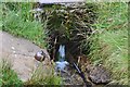
Whita Well above Langholm
A spring on the hillside with an iron drinking cup on a chain. The water was cold and fresh and an unexpected bonus on a warm afternoon.
Image: © Jim Barton
Taken: 13 Aug 2016
0.22 miles
2
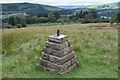
Cairn for Langholm Common Riding
A cairn close by the Whita Well, presumably on the annual Common Riding route. The plaque is dated 'Langholm Common Riding 1759 - 2009'.
Image: © Jim Barton
Taken: 13 Aug 2016
0.22 miles