IMAGES TAKEN NEAR TO
LANGHOLM, DG13 0HS
Introduction
This page details the photographs taken nearby to DG13 0HS by members of the Geograph project.
The Geograph project started in 2005 with the aim of publishing, organising and preserving representative images for every square kilometre of Great Britain, Ireland and the Isle of Man.

There are currently over 7.5m images from over14,400 individuals and you can help contribute to the project by visiting https://www.geograph.org.uk
Image Map (Loading...)


Getting Data...Please wait
Leaflet Map data © OpenStreetMap
Images are licensed for reuse under creativecommons.org/licenses/by-sa/2.0
Notes
- Clicking on the map will re-center to the selected point.
- The higher the marker number, the further away the image location is from the centre of the postcode.
Image Listing (3 Images Found)
Images are licensed for reuse under creativecommons.org/licenses/by-sa/2.0
Image
Details
Distance
1
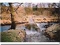
Ford, Tarras Water
A fairly shallow ford on the farm road between Perterburn and Middlemoss.
Image: © Andrew Smith
Taken: Unknown
0.11 miles
2
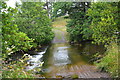
Tarras Water Ford
This ford on Tarras Water is found on the road leading to Peterburn. An image from 2005 can be seen at:
http://www.geograph.org.uk/photo/58597
and a video of the ford at:
https://vimeo.com/281088306
Image: © John Walton
Taken: 20 Jul 2018
0.14 miles
3
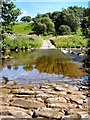
Ford crossing at Perterburn
Farm track crossing Perterburn from Cronksbank Farm
Image: © rob
Taken: 15 Jul 2006
0.14 miles