IMAGES TAKEN NEAR TO
LANGHOLM, DG13 0HR
Introduction
This page details the photographs taken nearby to DG13 0HR by members of the Geograph project.
The Geograph project started in 2005 with the aim of publishing, organising and preserving representative images for every square kilometre of Great Britain, Ireland and the Isle of Man.

There are currently over 7.5m images from over14,400 individuals and you can help contribute to the project by visiting https://www.geograph.org.uk
Image Map (Loading...)


Getting Data...Please wait
Leaflet Map data © OpenStreetMap
Images are licensed for reuse under creativecommons.org/licenses/by-sa/2.0
Notes
- Clicking on the map will re-center to the selected point.
- The higher the marker number, the further away the image location is from the centre of the postcode.
Image Listing (7 Images Found)
Images are licensed for reuse under creativecommons.org/licenses/by-sa/2.0
Image
Details
Distance
1
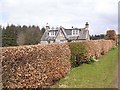
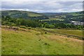
Hillhead
Nestling behind a well-kept beech hedge, the appropriately-named Hillhead overlooks Langholm and the valley of the Ewes Water.
Image: © Oliver Dixon
Taken: 13 Apr 2009
0.02 miles
2

Horse Training
Wattie Adams, exercising one of his horses in readiness for the racing season.
Image: © John Chroston
Taken: 13 Apr 2008
0.14 miles
3
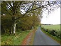
Langholm to Newcastleton road
The climb up to Langholm Moor.
Image: © Richard Webb
Taken: 14 Oct 2015
0.17 miles
4
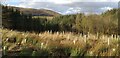
Clearfell above Langholm
Small area of clearfell above Langholm looking towards Potholm Hill.
Image: © Colin Kinnear
Taken: 21 Feb 2021
0.18 miles
5
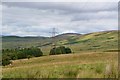
Power line on Whita Hill
A 132 kV overhead line heading north past Mosspaul into Teviotdale.
Image: © Jim Barton
Taken: 13 Aug 2016
0.21 miles
6
Path on Whita Hill
This path cuts diagonally up from Whita Road to meet the track coming up from the hill road that crosses the ridge further north.
Image: © Jim Barton
Taken: 13 Aug 2016
0.22 miles
7
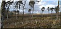
Whitshiels Knowe
Looking over Whitshiels Knowe where a small area has been clear felled and replanted with new saplings.
Image: © Colin Kinnear
Taken: 21 Feb 2021
0.23 miles