IMAGES TAKEN NEAR TO
LANGHOLM, DG13 0HP
Introduction
This page details the photographs taken nearby to DG13 0HP by members of the Geograph project.
The Geograph project started in 2005 with the aim of publishing, organising and preserving representative images for every square kilometre of Great Britain, Ireland and the Isle of Man.

There are currently over 7.5m images from over14,400 individuals and you can help contribute to the project by visiting https://www.geograph.org.uk
Image Map (Loading...)


Getting Data...Please wait
Leaflet Map data © OpenStreetMap
Images are licensed for reuse under creativecommons.org/licenses/by-sa/2.0
Notes
- Clicking on the map will re-center to the selected point.
- The higher the marker number, the further away the image location is from the centre of the postcode.
Image Listing (8 Images Found)
Images are licensed for reuse under creativecommons.org/licenses/by-sa/2.0
Image
Details
Distance
1
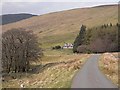
Glenrief and Crude Hill
Cottage near the mouth of the valley of Carewoodrig Burn.
Image: © Oliver Dixon
Taken: 13 Apr 2009
0.02 miles
2
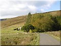
Glenrief
On the Hermitage road out of Ewesdale.
Image: © Richard Webb
Taken: 14 Oct 2015
0.04 miles
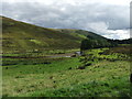
3
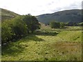
Carewoodrig Burn
A headwater of the Ewes Water.
Image: © Richard Webb
Taken: 14 Oct 2015
0.09 miles
5
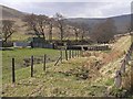
Livestock pens
In the valley of the Carewoodrig Burn.
Image: © Oliver Dixon
Taken: 13 Apr 2009
0.21 miles
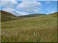
6
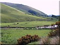
Rough grazing near Burnfoot
Rough grazing just off the A7.
Image: © Maigheach-gheal
Taken: 31 May 2008
0.22 miles
8
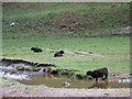
Cattle near Burnfoot
Cattle and sheep on rough grazing near Burnfoot. One enjoys the cooling water of the burn.
Image: © Maigheach-gheal
Taken: 31 May 2008
0.23 miles