
IMAGES TAKEN NEAR TO
LANGHOLM, DG13 0EP
Introduction
This page details the photographs taken nearby to DG13 0EP by members of the Geograph project.
The Geograph project started in 2005 with the aim of publishing, organising and preserving representative images for every square kilometre of Great Britain, Ireland and the Isle of Man.

There are currently over 7.5m images from over14,400 individuals and you can help contribute to the project by visiting https://www.geograph.org.uk
Image Map
Images are licensed for reuse under creativecommons.org/licenses/by-sa/2.0
Notes
- Clicking on the map will re-center to the selected point.
- The higher the marker number, the further away the image location is from the centre of the postcode.
Image Listing (192 Images Found)
Images are licensed for reuse under creativecommons.org/licenses/by-sa/2.0
Image
Details
Distance
6
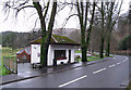
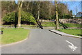
Visitor Information Centre, Langholm
The small building alongside the A7 is closed for the winter. The wooden area of decking which surrounds the building is roped off, with a small notice warning that it is slippery when wet.
Image: © Richard Dorrell
Taken: 24 Dec 2011
0.02 miles
8
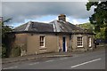
The South Toll Bar, Langholm
The South Toll Bar was once a place for passers by to stop off for a drink or two. According to the 'Langholm Heritage Trail Guide' it was not unusual to see up to thirty carts blocking the road, while the drivers were partaking of the 'Barley Brew' within!
Image: © John Chroston
Taken: 14 Sep 2013
0.02 miles
9
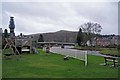
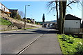
Riverside playpark
The river on the right is the Ewes Water, which joins the River Esk just before flowing beneath Langholm Bridge.
The church steeple on the left belongs to Erskine Church, which is closed. The steeple has been clad in scaffolding since at least 2008, when was photographed by Walter Baxter (Image]).
Image: © Richard Dorrell
Taken: 24 Dec 2011
0.02 miles
10
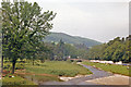
Langholm: northward up Ewes Water valley
The River Esk is coming in from the left. A caravan camp is beside A7 road and the Ewes Water.
Image: © Ben Brooksbank
Taken: 27 Jun 1986
0.03 miles