IMAGES TAKEN NEAR TO
Hallpath, LANGHOLM, DG13 0EG
Introduction
This page details the photographs taken nearby to Hallpath, DG13 0EG by members of the Geograph project.
The Geograph project started in 2005 with the aim of publishing, organising and preserving representative images for every square kilometre of Great Britain, Ireland and the Isle of Man.

There are currently over 7.5m images from over14,400 individuals and you can help contribute to the project by visiting https://www.geograph.org.uk
Image Map (Loading...)


Getting Data...Please wait
Leaflet Map data © OpenStreetMap
Images are licensed for reuse under creativecommons.org/licenses/by-sa/2.0
Notes
- Clicking on the map will re-center to the selected point.
- The higher the marker number, the further away the image location is from the centre of the postcode.
Image Listing (7 Images Found)
Images are licensed for reuse under creativecommons.org/licenses/by-sa/2.0
Image
Details
Distance
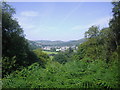
2
A lane in Langholm
At the southwest end of the town near the A7.
Image: © Walter Baxter
Taken: 26 Jan 2011
0.14 miles
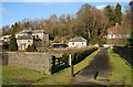
3
Former Tollhouse by the A7, Townfoot, Langholm
Townfoot Toll House by the A7, in parish of Langholm (Dumfries and Galloway District), Tollbar Cottage, Townfoot.
HES Scotland Category 'B' listed.
Reference: LB37135 http://portal.historicenvironment.scot/designation/LB37135
Surveyed
Milestone Society National ID: DG.LAN02
Image: © Milestone Society
Taken: Unknown
0.15 miles
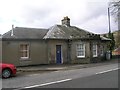
4
Former tollhouse
Surveyed by the Milestone Society. One of four Telford tollhouses of this design still to be seen north of the border on the Edinburgh road, now A7. This one is at the south end of Langholm at Townfoot. It has the typical castellated protruding front with windows giving good views in both directions. This tollhouse has been slightly modernised in that it has lost its central chimney.
Image: © Alverie Weighill
Taken: 10 May 2013
0.16 miles
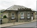
5
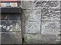
Ordnance Survey Cut Mark
This can be found on the wall of a factory building in Glenesk Road, Langholm.
For more detail see : http://www.bench-marks.org.uk/bm62487
Image: © Peter Wood
Taken: 25 Sep 2014
0.22 miles
6
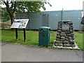
The last train cairn at Langholm
This cairn at Townfoot marks the site of the former railway station in the town. A branch line to Langholm from the Carlisle to Hawick railway line was opened on 18th April 1864 and closed to passengers on 15th June 1964. The last train left the station on 13th June 1964 and the line was completely closed on 18th September 1967. I chatted to an interesting old couple after I took this photo. They first met at Riccarton Junction on the Waverley Line and used to stay at Whitrope Cottages by the line. He worked on the railways and was on the last train that left Langholm. For more information about Langholm Station and the branch line, see http://www.disused-stations.org.uk/l/langholm/
Image: © Walter Baxter
Taken: 3 Aug 2013
0.23 miles
7
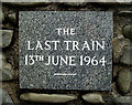
An inscribed stone on the last train cairn at Langholm
The cairn at Townfoot marks the site of the former railway station in the town. A branch line to Langholm from the Carlisle to Hawick railway line was opened on 18th April 1864 and closed to passengers on 15th June 1964. The last train left the station on 13th June 1964 and the line was completely closed on 18th September 1967. I chatted to an interesting old couple after I took this photo. They first met at Riccarton Junction on the Waverley Line and used to stay at Whitrope Cottages by the line. He worked on the railways and was on the last train that left Langholm. For more information about Langholm Station and the branch line, see http://www.disused-stations.org.uk/l/langholm/
For a view of the cairn, see Image
Image: © Walter Baxter
Taken: 3 Aug 2013
0.23 miles