IMAGES TAKEN NEAR TO
Grant Court, DUMFRIES, DG1 2RB
Introduction
This page details the photographs taken nearby to Grant Court, DG1 2RB by members of the Geograph project.
The Geograph project started in 2005 with the aim of publishing, organising and preserving representative images for every square kilometre of Great Britain, Ireland and the Isle of Man.

There are currently over 7.5m images from over14,400 individuals and you can help contribute to the project by visiting https://www.geograph.org.uk
Image Map (Loading...)


Getting Data...Please wait
Leaflet Map data © OpenStreetMap
Images are licensed for reuse under creativecommons.org/licenses/by-sa/2.0
Notes
- Clicking on the map will re-center to the selected point.
- The higher the marker number, the further away the image location is from the centre of the postcode.
Image Listing (176 Images Found)
Images are licensed for reuse under creativecommons.org/licenses/by-sa/2.0
Image
Details
Distance
1

Advert at St Michael's Services garage
Nith Inshore Rescue is an independent lifeboat serving the Dumfries area. We are based in Glencaple, 5 miles south of Dumfries in south-west Scotland, on the estuary of the River Nith close to where it joins the Solway Firth.
Image: © Russel Wills
Taken: 30 Sep 2021
0.03 miles

3

On your marks...
The start of Stage 6 of the Tour of Britain 2007.
Dock Park Dumfries.
Image: © Debbie Turner
Taken: 15 Sep 2007
0.06 miles
4

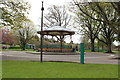
Bandstand, Dock Park
This was probably put up in the late 19th century. More information, and photos of the elaborate ironwork, are available on Canmore website http://canmore.rcahms.gov.uk/en/site/207954/details/dumfries+dock+park+bandstand/ .
The bandstand is in a bad state of repair and fenced off, with "Danger! Keep out" notices. Hopefully it will soon be restored, as part of a scheme to re-invigorate the Dock Park http://www.dumgal.gov.uk/index.aspx?articleid=9060 .
Image: © Rose and Trev Clough
Taken: 9 Jun 2012
0.06 miles

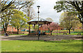
8
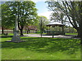
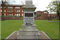
Titanic Memorial and Bandstand, Dock Park, Dumfries
Dock Park is situated beside the River Nith in Dumfries.
The Titanic Memorial is in memory of John Law Hume, a member of the band, and Thomas Mullen, steward, local natives, who both lost their lives in the sinking of the Titanic.
The bandstand probably dates from the late 19th century.
Image: © G Laird
Taken: 23 Apr 2017
0.06 miles
9
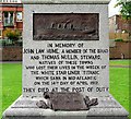
Inscription on the Titanic Memorial, Dock Park
The entire memorial is shown in this photo by another Geograph contributor Image .
The back of the plinth is inscribed "Erected by the people of Dumfries and Maxwelltown at home and abroad". In 1912 Dumfries and Maxwelltown were two separate burghs, they amalgamated in 1929 http://futuremuseum.co.uk/Collection.aspx/the_burgh_of_maxwelltown/Description .
Image: © Rose and Trev Clough
Taken: 9 Jun 2012
0.07 miles
10
Memorial to Crew of the Titanic
To John Law Hume and Thomas Mullin local men.
Image: © Billy McCrorie
Taken: 17 Apr 2017
0.07 miles