IMAGES TAKEN NEAR TO
Rosevale Street, DUMFRIES, DG1 2ER
Introduction
This page details the photographs taken nearby to Rosevale Street, DG1 2ER by members of the Geograph project.
The Geograph project started in 2005 with the aim of publishing, organising and preserving representative images for every square kilometre of Great Britain, Ireland and the Isle of Man.

There are currently over 7.5m images from over14,400 individuals and you can help contribute to the project by visiting https://www.geograph.org.uk
Image Map (Loading...)


Getting Data...Please wait
Leaflet Map data © OpenStreetMap
Images are licensed for reuse under creativecommons.org/licenses/by-sa/2.0
Notes
- Clicking on the map will re-center to the selected point.
- The higher the marker number, the further away the image location is from the centre of the postcode.
Image Listing (24 Images Found)
Images are licensed for reuse under creativecommons.org/licenses/by-sa/2.0
Image
Details
Distance
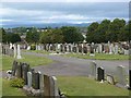
1
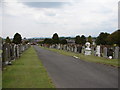
St Michael's Cemetery, Dumfries
St Michael's Cemetery (not to be confused with St Michael's Graveyard at the church) is a large cemetery to the north of Dumfries Cemetery. It contains 54 war graves and some notable gravestones, including the Pinter circus family grave (horse sculpture to right of central path) - see Image
Image: © Chris Newman
Taken: 21 May 2008
0.05 miles
3
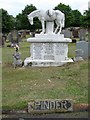
Pinder Grave, Dumfries
Pinder circus family grave in St Michael's Cemetery, Dumfries.
Image: © Chris Newman
Taken: 21 May 2008
0.11 miles
4
St Michael's Cemetery, Dumfries
Off Craig Road.
Image: © Oliver Dixon
Taken: 2 Sep 2013
0.15 miles
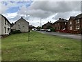
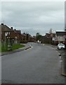
5
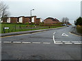
Larchfield
Rosevale Street here runs up into the Larchfield Estate in the south of Dumfries.
Image: © Andy Farrington
Taken: 26 Jan 2012
0.18 miles
7
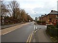
Brooms Road
View along towards Greenbrae, first right is Cresswell Avenue.
Image: © Andy Farrington
Taken: 26 Jan 2012
0.19 miles
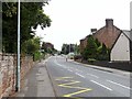
8
Westfield Road
View along to Eastfield Road ahead which runs down to the A756 Brooms Road.
Image: © Andy Farrington
Taken: 26 Jan 2012
0.20 miles
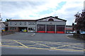
9
Dumfries Fire Station... including Watchtower
Dumfries Fire Station was opened in 1958.
Dumfries is the only Station in Dumfries and Galloway to have Wholetime Firefighter Crews.
Image: © Darrin Antrobus
Taken: 25 Mar 2007
0.20 miles