IMAGES TAKEN NEAR TO
Brooms Road, DUMFRIES, DG1 2EF
Introduction
This page details the photographs taken nearby to Brooms Road, DG1 2EF by members of the Geograph project.
The Geograph project started in 2005 with the aim of publishing, organising and preserving representative images for every square kilometre of Great Britain, Ireland and the Isle of Man.

There are currently over 7.5m images from over14,400 individuals and you can help contribute to the project by visiting https://www.geograph.org.uk
Image Map (Loading...)


Getting Data...Please wait
Leaflet Map data © OpenStreetMap
Images are licensed for reuse under creativecommons.org/licenses/by-sa/2.0
Notes
- Clicking on the map will re-center to the selected point.
- The higher the marker number, the further away the image location is from the centre of the postcode.
Image Listing (54 Images Found)
Images are licensed for reuse under creativecommons.org/licenses/by-sa/2.0
Image
Details
Distance
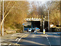
2
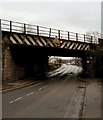
Bridge on Brooms Road
This rail bridge carries the main line into Dumfries station towards the left of picture. The warning lights on the bridge were on when I walked past suggesting it's been hit a view times by high sided vehicles.
Image: © Andy Farrington
Taken: 26 Jan 2012
0.07 miles
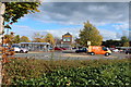
3
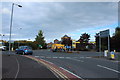
Brooms Road
View along towards Greenbrae, first right is Cresswell Avenue.
Image: © Andy Farrington
Taken: 26 Jan 2012
0.09 miles
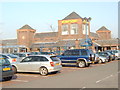
5
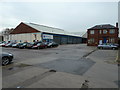
Stagecoach West Scotland
Bus depot off Eastfield Road in Dumfries.
Image: © Andy Farrington
Taken: 26 Jan 2012
0.10 miles
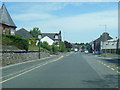
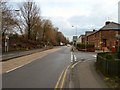
10
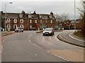
Brooms Road
View along this road which is the A756 and runs down to the left towards St Michael's Bridge.
Image: © Andy Farrington
Taken: 26 Jan 2012
0.16 miles