IMAGES TAKEN NEAR TO
Argyle Terrace, ANNAN, DG12 6SF
Introduction
This page details the photographs taken nearby to Argyle Terrace, DG12 6SF by members of the Geograph project.
The Geograph project started in 2005 with the aim of publishing, organising and preserving representative images for every square kilometre of Great Britain, Ireland and the Isle of Man.

There are currently over 7.5m images from over14,400 individuals and you can help contribute to the project by visiting https://www.geograph.org.uk
Image Map
Images are licensed for reuse under creativecommons.org/licenses/by-sa/2.0
Notes
- Clicking on the map will re-center to the selected point.
- The higher the marker number, the further away the image location is from the centre of the postcode.
Image Listing (9 Images Found)
Images are licensed for reuse under creativecommons.org/licenses/by-sa/2.0
Image
Details
Distance
1
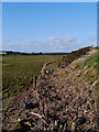
Washed Ashore
Marine debris and other detritus washed ashore by the recent storm surges along the Solway.
Image: © James T M Towill
Taken: 11 Feb 2014
0.17 miles
2
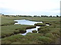
Pond on the salt marshes near Annan Waterfoot
A sea wall beyond.
Image: © Oliver Dixon
Taken: 2 Sep 2013
0.21 miles
3
Cow on the salt marshes near Annan Waterfoot
Image: © Dave Croker
Taken: 11 Sep 2024
0.22 miles
4
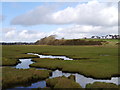
Pools In The Merse
One of several areas of semi-permanent flood water in the merse alongside the River Annan south of Annan.
Image: © James T M Towill
Taken: 11 Feb 2014
0.23 miles
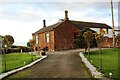
6
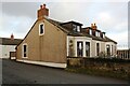
Hilltop House
Ordnance Survey documents indicate that a benchmark levelled at 34.316m above Newlyn Datum was verified in 1974 on the near corner, road face, of the house which is now pebbledashed above a concrete skirt
Image: © Luke Shaw
Taken: 4 Nov 2020
0.23 miles
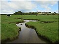
7
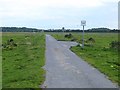
The road to Annan Waterfoot
Over the salt marshes. The bushes and trees are on Barnkirk Hill on the far side of the River Annan.
Image: © Oliver Dixon
Taken: 2 Sep 2013
0.23 miles
8
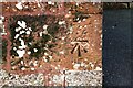
Benchmark on Hillend Farm House
Ordnance Survey records indicate that a benchmark levelled at 11.705m above Newlyn Datum was verified in 1974 at this location
Image: © Luke Shaw
Taken: 4 Nov 2020
0.24 miles
9
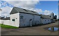
Hillend Farm on north side of Hillend Road
There is an Ordnance Survey benchmark Image on the near corner, left hand face, of the farmhouse
Image: © Luke Shaw
Taken: 4 Nov 2020
0.24 miles