IMAGES TAKEN NEAR TO
Carlisle Road, ANNAN, DG12 6RY
Introduction
This page details the photographs taken nearby to Carlisle Road, DG12 6RY by members of the Geograph project.
The Geograph project started in 2005 with the aim of publishing, organising and preserving representative images for every square kilometre of Great Britain, Ireland and the Isle of Man.

There are currently over 7.5m images from over14,400 individuals and you can help contribute to the project by visiting https://www.geograph.org.uk
Image Map (Loading...)


Getting Data...Please wait
Leaflet Map data © OpenStreetMap
Images are licensed for reuse under creativecommons.org/licenses/by-sa/2.0
Notes
- Clicking on the map will re-center to the selected point.
- The higher the marker number, the further away the image location is from the centre of the postcode.
Image Listing (14 Images Found)
Images are licensed for reuse under creativecommons.org/licenses/by-sa/2.0
Image
Details
Distance
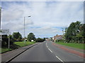
1
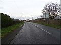
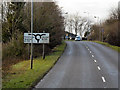
B721 west from Howgill
Roundabout sign can be sign in the distance
Image: © John Firth
Taken: 9 May 2012
0.02 miles
3
National Cycle Route 7
The B721 towards Eastriggs.
Image: © JThomas
Taken: 20 Nov 2019
0.03 miles
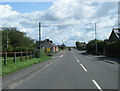
5
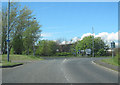
Roundabout at Watchhill
B721 entering Annan from the east
Image: © John Firth
Taken: 9 May 2012
0.07 miles
6
Stapleton Road, Annan
The B6357 approaches the junction with the B721 into Annan.
Image: © David Dixon
Taken: 14 Feb 2013
0.11 miles
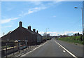
7
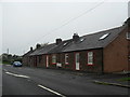
A row of cottages at Watchill
Sitting on the B721.
Image: © James Denham
Taken: 10 Sep 2010
0.14 miles