IMAGES TAKEN NEAR TO
ANNAN, DG12 6RR
Introduction
This page details the photographs taken nearby to DG12 6RR by members of the Geograph project.
The Geograph project started in 2005 with the aim of publishing, organising and preserving representative images for every square kilometre of Great Britain, Ireland and the Isle of Man.

There are currently over 7.5m images from over14,400 individuals and you can help contribute to the project by visiting https://www.geograph.org.uk
Image Map (Loading...)


Getting Data...Please wait
Leaflet Map data © OpenStreetMap
Images are licensed for reuse under creativecommons.org/licenses/by-sa/2.0
Notes
- Clicking on the map will re-center to the selected point.
- The higher the marker number, the further away the image location is from the centre of the postcode.
Image Listing (11 Images Found)
Images are licensed for reuse under creativecommons.org/licenses/by-sa/2.0
Image
Details
Distance
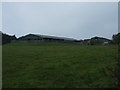
5
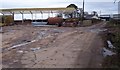
Scotsfield.
The new building is enormous when compared to the older buildings.
Image: © John Holmes
Taken: 25 Mar 2006
0.13 miles
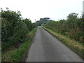
6
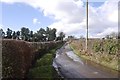
Scotsfield
A yellow road near Creca, Dumfriesshire.
Image: © Richard Webb
Taken: 5 Mar 2017
0.13 miles
7
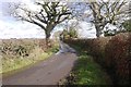
Yellow road, Eastfield
Near Creca, Dumfriesshire.
Image: © Richard Webb
Taken: 5 Mar 2017
0.16 miles
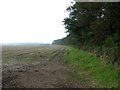
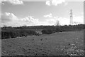
8
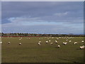
Pasture At Scotsfield
Closely-cropped sheep pasture at Scotsfield, near Creca.
Image: © James T M Towill
Taken: 16 Feb 2014
0.17 miles
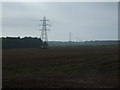
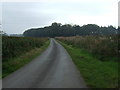
10
Waterlogged ground by Scotsfield
South of a minor road. The power line is one of those connected to the former power station/plutonium factory at Chapelcross.
Image: © Richard Webb
Taken: 5 Mar 2017
0.18 miles