IMAGES TAKEN NEAR TO
Creca, ANNAN, DG12 6RP
Introduction
This page details the photographs taken nearby to DG12 6RP by members of the Geograph project.
The Geograph project started in 2005 with the aim of publishing, organising and preserving representative images for every square kilometre of Great Britain, Ireland and the Isle of Man.

There are currently over 7.5m images from over14,400 individuals and you can help contribute to the project by visiting https://www.geograph.org.uk
Image Map (6 Images)


Getting Data...Please wait
Leaflet Map data © OpenStreetMap
Images are licensed for reuse under creativecommons.org/licenses/by-sa/2.0
Notes
- Clicking on the map will re-center to the selected point.
- The higher the marker number, the further away the image location is from the centre of the postcode.
Image Listing (6 Images Found)
Images are licensed for reuse under creativecommons.org/licenses/by-sa/2.0
Image
Details
Distance
1
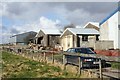
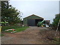
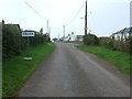
Creca Industrial Estate
The run down industrial estate in the hamlet of Creca.
Image: © Colin Kinnear
Taken: 10 Mar 2009
0.04 miles
6
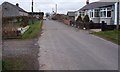
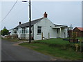
Creca.
A small hamlet with single storey dwellings.
Image: © John Holmes
Taken: 25 Mar 2006
0.18 miles