IMAGES TAKEN NEAR TO
ANNAN, DG12 6RA
Introduction
This page details the photographs taken nearby to DG12 6RA by members of the Geograph project.
The Geograph project started in 2005 with the aim of publishing, organising and preserving representative images for every square kilometre of Great Britain, Ireland and the Isle of Man.

There are currently over 7.5m images from over14,400 individuals and you can help contribute to the project by visiting https://www.geograph.org.uk
Image Map (Loading...)


Getting Data...Please wait
Leaflet Map data © OpenStreetMap
Images are licensed for reuse under creativecommons.org/licenses/by-sa/2.0
Notes
- Clicking on the map will re-center to the selected point.
- The higher the marker number, the further away the image location is from the centre of the postcode.
Image Listing (9 Images Found)
Images are licensed for reuse under creativecommons.org/licenses/by-sa/2.0
Image
Details
Distance
1
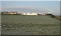
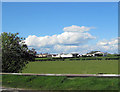
Swordwellrigg Farm
Viewed from the B721 on a crisp November morning.
Image: © Walter Baxter
Taken: 29 Nov 2008
0.02 miles
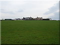
3
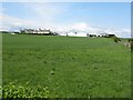
Swordwellrigg
Boring - this makes 75% of the images for this square of the same subject, but they allow comparisons to be made at different seasons - see Image and Image
Image: © M J Richardson
Taken: 26 Apr 2009
0.02 miles
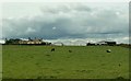
6
Grazing towards Swordwellrigg
Off the B721.
Image: © JThomas
Taken: 20 Nov 2019
0.07 miles
7
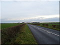
B721, Swordwell
National Cycle Route 7 towards Eastriggs.
Image: © JThomas
Taken: 20 Nov 2019
0.12 miles
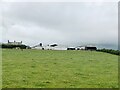
8
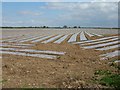
Crop protection at Swordwellrigg
Warming up the soil to bring on an early crop, probably potatoes
Image: © M J Richardson
Taken: 26 Apr 2009
0.15 miles
