IMAGES TAKEN NEAR TO
ANNAN, DG12 6QW
Introduction
This page details the photographs taken nearby to DG12 6QW by members of the Geograph project.
The Geograph project started in 2005 with the aim of publishing, organising and preserving representative images for every square kilometre of Great Britain, Ireland and the Isle of Man.

There are currently over 7.5m images from over14,400 individuals and you can help contribute to the project by visiting https://www.geograph.org.uk
Image Map (Loading...)


Getting Data...Please wait
Leaflet Map data © OpenStreetMap
Images are licensed for reuse under creativecommons.org/licenses/by-sa/2.0
Notes
- Clicking on the map will re-center to the selected point.
- The higher the marker number, the further away the image location is from the centre of the postcode.
Image Listing (5 Images Found)
Images are licensed for reuse under creativecommons.org/licenses/by-sa/2.0
Image
Details
Distance
1
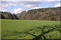
Gill Wood
Woodland beyond a grass field near Woodhead with the shadow of one of the roadside ashes on the B6357.
Image: © Richard Webb
Taken: 5 Mar 2017
0.07 miles
2
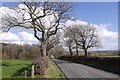
B6357, Woodhead
Tree lined road towards Stapleton.
Image: © Richard Webb
Taken: 5 Mar 2017
0.09 miles
5
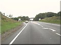
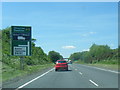
Approaching the turning to Annan on the A75
Image: © Ann Cook
Taken: 18 Sep 2010
0.25 miles