IMAGES TAKEN NEAR TO
Halifax Road, ANNAN, DG12 6QF
Introduction
This page details the photographs taken nearby to Halifax Road, DG12 6QF by members of the Geograph project.
The Geograph project started in 2005 with the aim of publishing, organising and preserving representative images for every square kilometre of Great Britain, Ireland and the Isle of Man.

There are currently over 7.5m images from over14,400 individuals and you can help contribute to the project by visiting https://www.geograph.org.uk
Image Map (Loading...)


Getting Data...Please wait
Leaflet Map data © OpenStreetMap
Images are licensed for reuse under creativecommons.org/licenses/by-sa/2.0
Notes
- Clicking on the map will re-center to the selected point.
- The higher the marker number, the further away the image location is from the centre of the postcode.
Image Listing (24 Images Found)
Images are licensed for reuse under creativecommons.org/licenses/by-sa/2.0
Image
Details
Distance
1
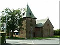
St. John's Episcopal Church, Eastriggs
A church in the Arts and Crafts style, built in 1917 http://hsewsf.sedsh.gov.uk/hslive/hsstart?P_HBNUM=3787 .
The township of Eastriggs was created during World War I to house thousands of workers at a vast new munitions site - H.M. Factory, Gretna http://en.wikipedia.org/wiki/HM_Factory,_Gretna .
Image: © Rose and Trev Clough
Taken: 28 Jul 2007
0.04 miles
2
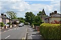
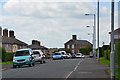
Ladysmith Road, Eastriggs
A side road off Annan Road. The low spire is St John's Episcopal Church.
Image: © Jim Barton
Taken: 8 Aug 2016
0.06 miles
3
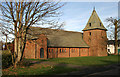
St John's Episcopal Church at Eastriggs
This Early Gothic style church on Dunedin Road was opened in 1917.
Image: © Walter Baxter
Taken: 25 Nov 2008
0.06 miles
4
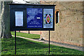
Church sign at Eastriggs
At the Episcopal church in Dunedin Road Image
Image: © Walter Baxter
Taken: 25 Nov 2008
0.06 miles
5
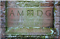
Inscribed stone at St John's Episcopal Church, Eastriggs
A dedication stone on the east face of the building, dated 1917.
Image: © Walter Baxter
Taken: 25 Nov 2008
0.06 miles
6
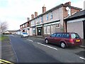
Row of shops at Eastriggs
Built during Great War for workers at the munitions factory and sold by HM Treasury in 1921. Includes the post office at the far end.
Image: © Oliver Dixon
Taken: 29 Jan 2014
0.08 miles
7
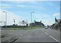
Car Park entrance from B721 at Eastriggs
At The Green
Image: © John Firth
Taken: 9 May 2012
0.08 miles
9
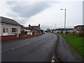
The Rand, Eastriggs
A residential road on the south side of the village which once housed workers from the cordite factory in World War 1.
Image: © Jim Barton
Taken: 8 Aug 2016
0.10 miles
10
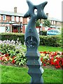
Millennium milepost at Eastriggs
1,000 of these posts, funded by the Royal Bank of Scotland, mark the National Cycle Network. Many around the UK have been Geographed.
Image: © Rose and Trev Clough
Taken: 28 Jul 2007
0.11 miles