IMAGES TAKEN NEAR TO
The Crescent, ANNAN, DG12 6NW
Introduction
This page details the photographs taken nearby to The Crescent, DG12 6NW by members of the Geograph project.
The Geograph project started in 2005 with the aim of publishing, organising and preserving representative images for every square kilometre of Great Britain, Ireland and the Isle of Man.

There are currently over 7.5m images from over14,400 individuals and you can help contribute to the project by visiting https://www.geograph.org.uk
Image Map (Loading...)


Getting Data...Please wait
Leaflet Map data © OpenStreetMap
Images are licensed for reuse under creativecommons.org/licenses/by-sa/2.0
Notes
- Clicking on the map will re-center to the selected point.
- The higher the marker number, the further away the image location is from the centre of the postcode.
Image Listing (14 Images Found)
Images are licensed for reuse under creativecommons.org/licenses/by-sa/2.0
Image
Details
Distance
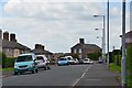
3
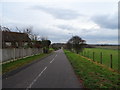
The Ridge, Eastriggs
A road on the southern side of the village, continuing from Vancouver Road.
Image: © Jim Barton
Taken: 8 Aug 2016
0.14 miles
4
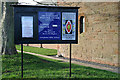
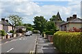
Church sign at Eastriggs
At the Episcopal church in Dunedin Road Image
Image: © Walter Baxter
Taken: 25 Nov 2008
0.17 miles
5
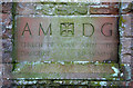
Inscribed stone at St John's Episcopal Church, Eastriggs
A dedication stone on the east face of the building, dated 1917.
Image: © Walter Baxter
Taken: 25 Nov 2008
0.17 miles
6
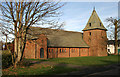
St John's Episcopal Church at Eastriggs
This Early Gothic style church on Dunedin Road was opened in 1917.
Image: © Walter Baxter
Taken: 25 Nov 2008
0.17 miles
7
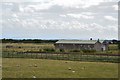
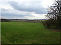
Buildings and railway remains, Eastriggs cordite factory
These old railway lines and buildings on the S side of the village are remnants of the extensive complex of HM Factory Gretna that stretched 9 miles by the Solway almost to Longtown.
Image: © Jim Barton
Taken: 8 Aug 2016
0.17 miles
8
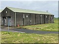
Shed in Eastriggs Depot
A remnant of narrow gauge track from the once extensive 2' gauge system in Eastriggs Depot can be discerned in front of the left hand end of the shed.
Image: © Adrian Taylor
Taken: 14 Sep 2024
0.18 miles
9
Ladysmith Road, Eastriggs
A side road off Annan Road. The low spire is St John's Episcopal Church.
Image: © Jim Barton
Taken: 8 Aug 2016
0.18 miles
10
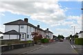
The Rand, Eastriggs
A residential road on the south side of the village which once housed workers from the cordite factory in World War 1.
Image: © Jim Barton
Taken: 8 Aug 2016
0.18 miles