IMAGES TAKEN NEAR TO
Delhi Road, ANNAN, DG12 6NT
Introduction
This page details the photographs taken nearby to Delhi Road, DG12 6NT by members of the Geograph project.
The Geograph project started in 2005 with the aim of publishing, organising and preserving representative images for every square kilometre of Great Britain, Ireland and the Isle of Man.

There are currently over 7.5m images from over14,400 individuals and you can help contribute to the project by visiting https://www.geograph.org.uk
Image Map (Loading...)


Getting Data...Please wait
Leaflet Map data © OpenStreetMap
Images are licensed for reuse under creativecommons.org/licenses/by-sa/2.0
Notes
- Clicking on the map will re-center to the selected point.
- The higher the marker number, the further away the image location is from the centre of the postcode.
Image Listing (12 Images Found)
Images are licensed for reuse under creativecommons.org/licenses/by-sa/2.0
Image
Details
Distance
1
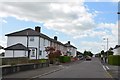
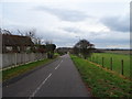
The Ridge, Eastriggs
A road on the southern side of the village, continuing from Vancouver Road.
Image: © Jim Barton
Taken: 8 Aug 2016
0.09 miles
2
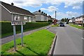
Pretoria Road, Eastriggs
One of the roads in the 'Commonwealth Village' of Eastriggs built to house workers in the large munitions factory created here in WWI.
Image: © Jim Barton
Taken: 8 Aug 2016
0.09 miles
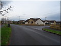
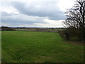
4
Vancouver Drive, Eastriggs
Newish bungalows on the edge of the village.
Image: © JThomas
Taken: 20 Nov 2019
0.11 miles
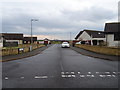
7
Ottawa Road, Eastriggs
Another name in the Commonwealth theme in this planned village that housed some of the workforce in the vast cordite factory complex in World War 1.
Image: © Jim Barton
Taken: 8 Aug 2016
0.21 miles
8
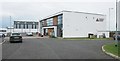
Devil's Porridge Museum, Eastriggs
The museum opened on this site in 2014. It gives an insight into the huge explosives factory constructed from Eastriggs to Gretna and Longtown during the First World War. More recent displays look at the impact of the Second World War on the area, and bring the story right up to date with information about the now decommissioned Chapelhall Power Station.
Image: © Richard Sutcliffe
Taken: 19 May 2017
0.23 miles
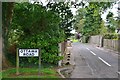
9
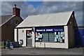
Shop and newsagents, Eastriggs
A local shop on Annan Road, not far from the Devil's Porridge Museum.
Image: © Jim Barton
Taken: 8 Aug 2016
0.23 miles
10
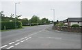
Annan Road (B721)
From the junction with Victoria Gardens.
Image: © Richard Sutcliffe
Taken: 19 May 2017
0.23 miles