IMAGES TAKEN NEAR TO
Kimmeter Place, ANNAN, DG12 6JU
Introduction
This page details the photographs taken nearby to Kimmeter Place, DG12 6JU by members of the Geograph project.
The Geograph project started in 2005 with the aim of publishing, organising and preserving representative images for every square kilometre of Great Britain, Ireland and the Isle of Man.

There are currently over 7.5m images from over14,400 individuals and you can help contribute to the project by visiting https://www.geograph.org.uk
Image Map (Loading...)


Getting Data...Please wait
Leaflet Map data © OpenStreetMap
Images are licensed for reuse under creativecommons.org/licenses/by-sa/2.0
Notes
- Clicking on the map will re-center to the selected point.
- The higher the marker number, the further away the image location is from the centre of the postcode.
Image Listing (7 Images Found)
Images are licensed for reuse under creativecommons.org/licenses/by-sa/2.0
Image
Details
Distance
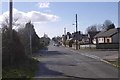
3
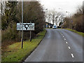
Stapleton Road, Annan
The B6357 approaches the junction with the B721 into Annan.
Image: © David Dixon
Taken: 14 Feb 2013
0.17 miles
4
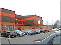
Shop in housing estate, Shawhill Road, Annan
Image: © Darrin Antrobus
Taken: 20 Feb 2008
0.21 miles
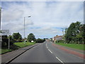
5
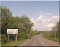
The old Stapleton Road, Gallaberry
A straight road into Annan which has been replaced by a new alignment to the east.
Image: © Richard Webb
Taken: 5 Mar 2017
0.21 miles
7
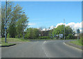
Roundabout at Watchhill
B721 entering Annan from the east
Image: © John Firth
Taken: 9 May 2012
0.24 miles