IMAGES TAKEN NEAR TO
Glynt View, ANNAN, DG12 6GA
Introduction
This page details the photographs taken nearby to Glynt View, DG12 6GA by members of the Geograph project.
The Geograph project started in 2005 with the aim of publishing, organising and preserving representative images for every square kilometre of Great Britain, Ireland and the Isle of Man.

There are currently over 7.5m images from over14,400 individuals and you can help contribute to the project by visiting https://www.geograph.org.uk
Image Map (1 Images)


Getting Data...Please wait
Leaflet Map data © OpenStreetMap
Images are licensed for reuse under creativecommons.org/licenses/by-sa/2.0
Notes
- Clicking on the map will re-center to the selected point.
- The higher the marker number, the further away the image location is from the centre of the postcode.
Image Listing (1 Images Found)
Images are licensed for reuse under creativecommons.org/licenses/by-sa/2.0
Image
Details
Distance
1
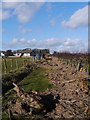
Obstructions On The Coastal Path
The track south of Summergate showing the effect of recent storm surges which have deposited vegetation as well as marine debris.
Image: © James T M Towill
Taken: 11 Feb 2014
0.25 miles