IMAGES TAKEN NEAR TO
Summergate Crescent, ANNAN, DG12 6EU
Introduction
This page details the photographs taken nearby to Summergate Crescent, DG12 6EU by members of the Geograph project.
The Geograph project started in 2005 with the aim of publishing, organising and preserving representative images for every square kilometre of Great Britain, Ireland and the Isle of Man.

There are currently over 7.5m images from over14,400 individuals and you can help contribute to the project by visiting https://www.geograph.org.uk
Image Map (Loading...)


Getting Data...Please wait
Leaflet Map data © OpenStreetMap
Images are licensed for reuse under creativecommons.org/licenses/by-sa/2.0
Notes
- Clicking on the map will re-center to the selected point.
- The higher the marker number, the further away the image location is from the centre of the postcode.
Image Listing (51 Images Found)
Images are licensed for reuse under creativecommons.org/licenses/by-sa/2.0
Image
Details
Distance
1

Pipeband practice disrupted
A pipeband competition is held annually as part of the Annan Riding of the Marches event http://www.annan.org.uk/rom/pipeband_contest.html . The bands warm up beforehand, grouped around the sports field of Annan Academy. In the evening, they perform in the town centre Image .
In the background, buildings of Annan Academy (left) and Hecklegirth Primary School (right).
Image: © Rose and Trev Clough
Taken: 3 Jul 2010
0.07 miles
2
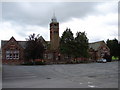
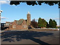
Annan Academy
The older Annan Academy buildings were erected 1894-6 in Jacobean detail with a tall tower in the centre of building.
Image: © Chris Newman
Taken: 15 Jul 2008
0.10 miles
3
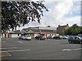
Annan swimming pool and car park
Situated on the Annan Academy school campus, the pool is a dual use facility and is available for public use in school-time evenings and during holidays. The building also houses a games hall.
Image: © Richard Dorrell
Taken: 14 Jun 2013
0.11 miles
4

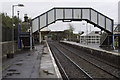
Benchmark on NW parapet of railway bridge at NE end of Elm Road
Ordnance Survey pivot benchmark described on the Bench Mark Database at www.bench-marks.org.uk/bm134446
Image: © Luke Shaw
Taken: 29 Oct 2020
0.12 miles
5
Elm Road railway bridge east of station at Summergate Road junction
There is an Ordnance Survey benchmark on top of the left hand bridge parapet
Image: © Luke Shaw
Taken: 29 Oct 2020
0.12 miles
6
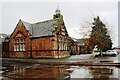
Annan: older buildings of Annan Academy
The 1890s buildings of the Annan Academy, which are still used as the school's library, although the main buildings are now the 1960s buildings which just seak into the left-hand edge of the picture.
Image: © Chris Downer
Taken: 23 Jul 2011
0.12 miles
7
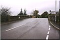
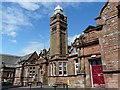
Annan Academy
There is an Ordnance Survey benchmark Image on the near corner, right hand face, of the building
Image: © Luke Shaw
Taken: 29 Oct 2020
0.12 miles
8
Victorian building at Annan Academy
A closer view of the building shown at Image . The Academy website has information about the school's history http://www.annanacademy.org.uk/School_info/School_Info.html .
Image: © Rose and Trev Clough
Taken: 3 Jul 2010
0.12 miles
9
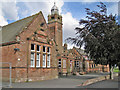
Annan Academy
Built by George McIldowiebell in 1895, these red sandstone buildings were extended in the 1960s and now form part of a secondary school with over 1100 pupils on roll. See also: Image
Image: © Richard Dorrell
Taken: 14 Jun 2013
0.13 miles