IMAGES TAKEN NEAR TO
Wood Avenue, ANNAN, DG12 6DA
Introduction
This page details the photographs taken nearby to Wood Avenue, DG12 6DA by members of the Geograph project.
The Geograph project started in 2005 with the aim of publishing, organising and preserving representative images for every square kilometre of Great Britain, Ireland and the Isle of Man.

There are currently over 7.5m images from over14,400 individuals and you can help contribute to the project by visiting https://www.geograph.org.uk
Image Map (Loading...)


Getting Data...Please wait
Leaflet Map data © OpenStreetMap
Images are licensed for reuse under creativecommons.org/licenses/by-sa/2.0
Notes
- Clicking on the map will re-center to the selected point.
- The higher the marker number, the further away the image location is from the centre of the postcode.
Image Listing (72 Images Found)
Images are licensed for reuse under creativecommons.org/licenses/by-sa/2.0
Image
Details
Distance
1
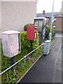
Annan: postbox № DG12 201 and phone, Wood Avenue
This small postbox and phone box serve a fairly modern housing area to the south of the town. This side of the postbox is a drop box (see below).
Image: © Chris Downer
Taken: 4 Aug 2012
0.01 miles
2
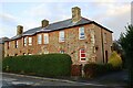
Houses on east side of Waterfoot Road
There is an Ordnance Survey benchmark Image on the near corner of the nearest house above its side path
Image: © Roger Templeman
Taken: 4 Nov 2020
0.09 miles
3

Benchmark on #56 Waterfoot Road
Ordnance Survey cut mark benchmark levelled at 7.321m above Newlyn Datum verified in 1974
Image: © Roger Templeman
Taken: 4 Nov 2020
0.09 miles
4

Murals at Port Street, Annan
The murals are on the east side of this street near the quayside.
Image: © Walter Baxter
Taken: 8 Jan 2014
0.11 miles
5
Annan 'Sky Hook'
As part of the tidying up of Annans Quayside.
Image: © Sarah Clark
Taken: 15 Jul 2016
0.11 miles
6
A mural at Port Street, Annan
This is at the quayside area at Annan Harbour.
Image: © Walter Baxter
Taken: 8 Jan 2014
0.11 miles
7
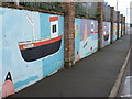
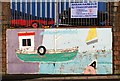
Annan: mural near the harbour
The walls along Port Street on the immediate approach to the harbour have had these murals painted along them. The boat here cleverly uses the town's postcode, DG12, as the registration number.
Image: © Chris Downer
Taken: 4 Aug 2012
0.11 miles
8
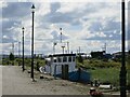
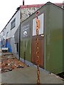
Part of Annan Harbour
This area is due to be redeveloped https://www.annanharbour.org.uk/
Image: © Dave Croker
Taken: 11 Sep 2024
0.12 miles
9
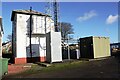
Signal box and comms mast beside railway west of Annan Station
There is an Ordnance Survey benchmark Image on the left hand side of the signal box at its front corner
Image: © Luke Shaw
Taken: 4 Nov 2020
0.12 miles
10
Port Street, Annan
This was viewed from the quayside at the harbour area. Various murals have been painted on a low concrete block wall.
Image: © Walter Baxter
Taken: 8 Jan 2014
0.12 miles