IMAGES TAKEN NEAR TO
Nicholson Place, ANNAN, DG12 6BS
Introduction
This page details the photographs taken nearby to Nicholson Place, DG12 6BS by members of the Geograph project.
The Geograph project started in 2005 with the aim of publishing, organising and preserving representative images for every square kilometre of Great Britain, Ireland and the Isle of Man.

There are currently over 7.5m images from over14,400 individuals and you can help contribute to the project by visiting https://www.geograph.org.uk
Image Map (Loading...)


Getting Data...Please wait
Leaflet Map data © OpenStreetMap
Images are licensed for reuse under creativecommons.org/licenses/by-sa/2.0
Notes
- Clicking on the map will re-center to the selected point.
- The higher the marker number, the further away the image location is from the centre of the postcode.
Image Listing (66 Images Found)
Images are licensed for reuse under creativecommons.org/licenses/by-sa/2.0
Image
Details
Distance
1
Annan 'Sky Hook'
As part of the tidying up of Annans Quayside.
Image: © Sarah Clark
Taken: 15 Jul 2016
0.07 miles
2

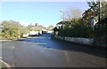
Benchmark on wall on SE side of Port Street opposite Riverside Walk
Ordnance Survey cut mark benchmark described on the Bench Mark Database at www.bench-marks.org.uk/bm134448
Image: © Luke Shaw
Taken: 4 Nov 2020
0.09 miles
3
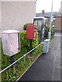
Annan: postbox № DG12 201 and phone, Wood Avenue
This small postbox and phone box serve a fairly modern housing area to the south of the town. This side of the postbox is a drop box (see below).
Image: © Chris Downer
Taken: 4 Aug 2012
0.09 miles
4
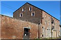
Warehouse conversion, Port Street, Annan
Image: © Leslie Barrie
Taken: 7 Aug 2014
0.11 miles
5
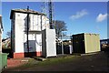
Signal box and comms mast beside railway west of Annan Station
There is an Ordnance Survey benchmark Image on the left hand side of the signal box at its front corner
Image: © Luke Shaw
Taken: 4 Nov 2020
0.12 miles
6
Looking NE along Port Street at Riverside Walk junction
There is an Ordnance Survey benchmark Image on the wall at the right hand side of the road where there is a wall pier
Image: © Luke Shaw
Taken: 4 Nov 2020
0.12 miles
7
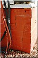
Benchmark on signal box west of Annan Station
Ordnance Survey cut mark benchmark described on the Bench Mark Database at www.bench-marks.org.uk/bm134447
Image: © Luke Shaw
Taken: 4 Nov 2020
0.13 miles
8
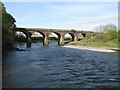
Railway Bridge at Annan
The bridge carries the Glasgow South Western Line across the River Annan about half a mile west of Annan railway station.
Image: © G Laird
Taken: 23 Apr 2017
0.13 miles
9

Annan Millennium Bridge
This footbridge over the River Annan was opened in 2002 and is used by the Annandale Way long-distance footpath.
Image: © Jim Barton
Taken: 14 Jul 2021
0.13 miles
10
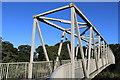
Annan Millennium Bridge
Carries National Cycle Network Route 7 over the River Annan
Image: © Leslie Barrie
Taken: 7 Aug 2014
0.13 miles