IMAGES TAKEN NEAR TO
Riverside Walk, ANNAN, DG12 6BE
Introduction
This page details the photographs taken nearby to Riverside Walk, DG12 6BE by members of the Geograph project.
The Geograph project started in 2005 with the aim of publishing, organising and preserving representative images for every square kilometre of Great Britain, Ireland and the Isle of Man.

There are currently over 7.5m images from over14,400 individuals and you can help contribute to the project by visiting https://www.geograph.org.uk
Image Map (Loading...)


Getting Data...Please wait
Leaflet Map data © OpenStreetMap
Images are licensed for reuse under creativecommons.org/licenses/by-sa/2.0
Notes
- Clicking on the map will re-center to the selected point.
- The higher the marker number, the further away the image location is from the centre of the postcode.
Image Listing (103 Images Found)
Images are licensed for reuse under creativecommons.org/licenses/by-sa/2.0
Image
Details
Distance
1
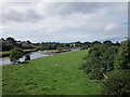
Annan Millennium Bridge
Carries National Cycle Network Route 7 over the River Annan
Image: © Leslie Barrie
Taken: 7 Aug 2014
0.07 miles
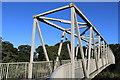
2

Annan Millennium Bridge
This footbridge over the River Annan was opened in 2002 and is used by the Annandale Way long-distance footpath.
Image: © Jim Barton
Taken: 14 Jul 2021
0.07 miles
3
Newbie Bridge, Annan
Taken from a Dumfries to Carlisle train as it crossed the River Annan, this gives a different view of Image For more information on this cycle and pedestrian bridge see http://www.dumgal.gov.uk/dumgal/MiniWeb.aspx?id=328&menuid=4831&openid=4830&pageid=7082
Image: © Rose and Trev Clough
Taken: 16 Aug 2008
0.07 miles
4

Benchmark on wall on SE side of Port Street opposite Riverside Walk
Ordnance Survey cut mark benchmark described on the Bench Mark Database at www.bench-marks.org.uk/bm134448
Image: © Luke Shaw
Taken: 4 Nov 2020
0.08 miles
5
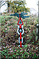
National Cycle Network signpost, Annan
On the loop rising to Annan Millennium Bridge
Millennium Time Trail ID: MP357 see http://umap.openstreetmap.fr/en/map/sustrans-mileposts_71773#12/54.9801/-3.2777
Image: © Luke Shaw
Taken: 7 Nov 2020
0.08 miles
6

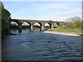
Annan Viaduct
Red ashlar railway viaduct carrying double track over the River Annan. Built for the Glasgow, Dumfries and Carlisle railway whose line opened in 1848.
Category B listed building (LB21062 http://portal.historicenvironment.scot/designation/LB21062 Historic Environment Scotland).
Image: © David Dixon
Taken: 9 Aug 2021
0.08 miles
7

Annan Viaduct
The Annan Viaduct was built in 1848 for the Glasgow, Dumfries and Carlisle Railway.
The Annan Millennium Bridge is visible beyond the viaduct.
Image: © Adrian Taylor
Taken: 12 Nov 2013
0.08 miles
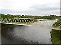
8
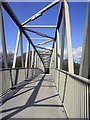
Annan Millennium Bridge
A new bridge at Annan which carries the National Cycle Network route 7 over the River Annan.
Image: © Colin Kinnear
Taken: 20 Apr 2010
0.08 miles
9
Railway Bridge at Annan
The bridge carries the Glasgow South Western Line across the River Annan about half a mile west of Annan railway station.
Image: © G Laird
Taken: 23 Apr 2017
0.09 miles